Whangarei
17.89°C

Whangarei
17.89°C
Waitakere City
16.98°C
Manukau City
17.11°C

Papakura
24.46°C
Hauraki
17.26°C

Waikato
17.67°C
Matamata
18.46°C
Hamilton
17.51°C
Otorohanga
18.52°C
Rotorua
16.6°C
Taupo
15.44°C
Tauranga
19.27°C
Kawerau
18.6°C
Whakatane
19.64°C
Gisborne
15.51°C
New Plymouth
16.98°C

Stratford
8.97°C
Ruapehu
14°C
Wanganui
17°C
Palmerston North
16.41°C
Wairoa
19.19°C
Hastings
18.84°C
Napier
18.49°C
Masterton
15.49°C
Carterton
15.66°C
Porirua
15.99°C
Lower Hutt
16.45°C

Wellington
15.79°C

Tasman
9.35°C
Nelson
16.27°C
Marlborough
3.22°C
Kaikoura
15.48°C
Christchurch
12.59°C
Ashburton
12.52°C
Timaru
13.37°C
Waitaki
11.32°C
Waimate
13.08°C

Queenstown
12.38°C
Dunedin
14.33°C
Southland
9.98°C
Gore
11.31°C
Invercargill
12.06°C
Blenheim
14.73°C
Te Anau
27.35°C
Wanaka
11.17°C
Kaikoura
13.38°C
Stratford
13.54°C
Upper Hutt
15.9°C
About


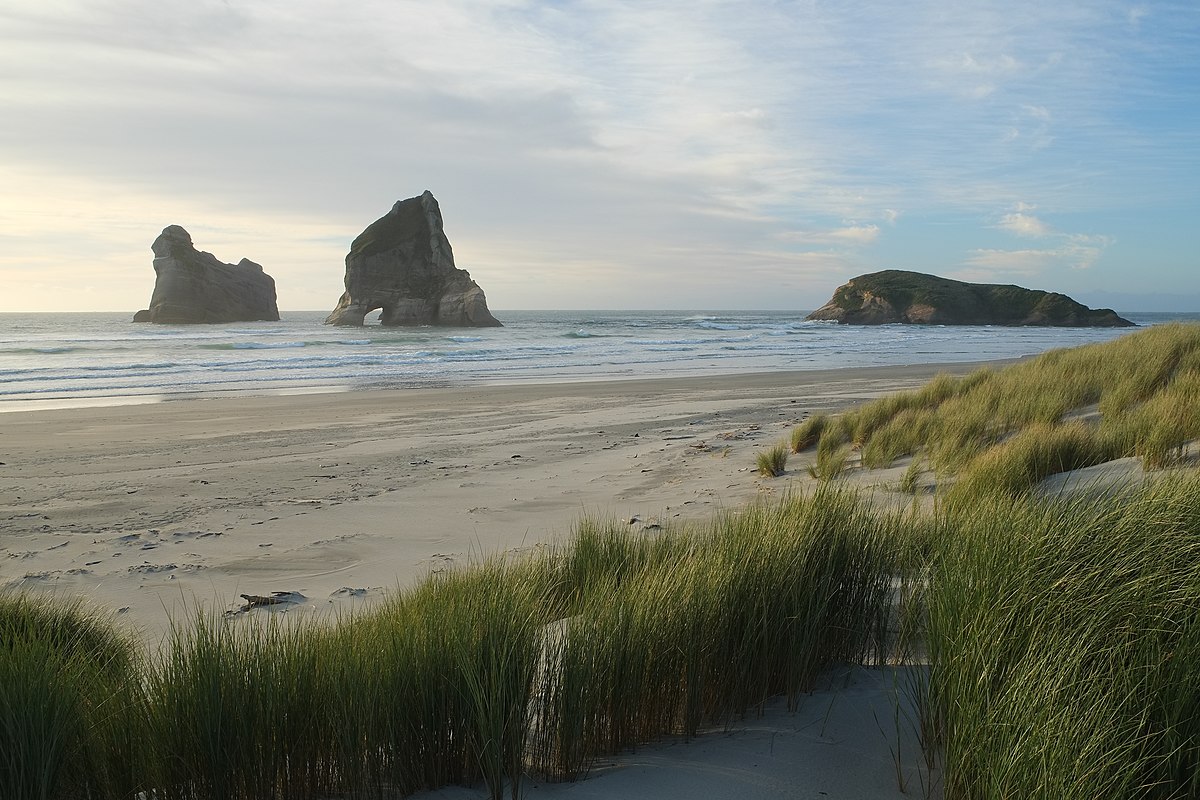
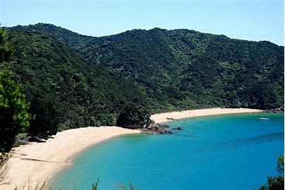
A easy walk along the most spectacular coastline in the region, passing through farmland and forest.
The track to Wharariki Beach travels over farm paddocks and through a section of coastal forest, before arriving a the beautiful windswept coast.
The best time to visit is at low tide, when you can walk the length of the beach and take in spectacular coastlines, caverns, islands, and enormous sand dunes along the way.
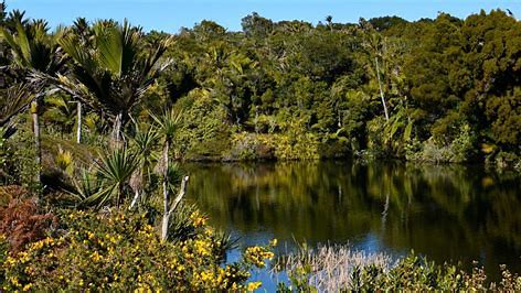
From Takaka, head north along State Highway 60 to Collingwood, which is where State Highway 60 ends. Continue north along Collingwood-Puponga Main Rd to Pakawau and turn left onto Pakawau Bush Rd, which turns to gravel as it reaches Whanganui Inlet. Turn right onto Kaihoka Lakes Rd, and follow it for 6 km until you see Kaihoka Lakes Scenic Reserve on the right. There is a small parking area and toilet next to the first lake. The track heads above the edge of the first lake through thick nikau and ferns. It continues in a more or less straight line to the edge of the second lake, where it ends. Here you will need to turn around to return the way you came. Do not try to get to the coast as the land surrounding the track is private. The respective Maori names of the eastern and western lakes are Tinawhu and Whupa. Neither lake has permanent inflows or outflows, meaning their levels are controlled by rainfall, seepage and evaporation. They are relatively young, having formed as sand dunes migrated eastward from the coast. This process created basins that lacked a drainage path to the coast. Over time, water accumulated, transforming the basins into a swamps, and then lakes.
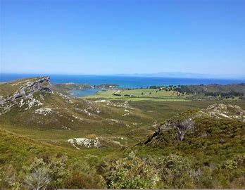
From the car park, Kaituna Track follows an old forestry road along a spur through regenerating mixed podocarp forest. The track has a gentle uphill gradient most of the way. Occasional gaps in the trees allow glimpses towards the coast, and Knuckle Hill can be see ahead. After 4 km you will reach the turnoff to Knuckle Hill. If you’re riding you’ll have to leave your bike here as the remaining distance is unrideable. The track emerges into pakihi scrub of manuka and tussock, with sandy granite rocks underfoot. At this point the track steepens as you climb the remaining 150 vertical metres to the trig at the summit. The 506 m elevation summit offers stunning views; Knuckle Hill is the only sufficiently-prominent location able to provide views of the entire Whanganui Inlet. You will also enjoy views of western side of Burnett Range, the forested hill country southwest between the coast and Wakamarama Range, and on clear days you may be able to see Kahurangi Point Lighthouse. Return from the summit the way you came. Once back at the Kaituna Track, turn right to head back to the car park. Otherwise, Kaituna Track heads left and continues for a further 14 km to Aorere Valley.
The car park is next to the turbine house that has a viewing platform. The walkway is a loop and can be completed in either direction. The climb will be less steep if you do it in a clockwise direction. Begin along Pupu Hydro Society’s gravel access road, which winds gently up through young mixed podocarp forest on a spur south of Campbell Creek. There is a lookout point halfway along that provides views east toward Takaka Valley. Along here you will encounter magnificent, tall rimu with epiphytes hanging off. After 2.7 km the road dips down to meet Campbell Creek, where the intake weir diverting flow into the water race is located. The road ends and a footbridge crosses the creek to join the water race. For the next 1.6 km, the walkway runs directly alongside the water race as it contours the hillside. The water is crystal-clear and the hillside is forested in lush native bush. The water race is actually part canal, part aqueduct, with some sections suspended over gullies and steep parts of the hillside. Along the particularly steep sections of the hillside the walkway becomes a boardwalk less than half a metre wide, and overhangs the water race. A guard rail gives protection from the steep drop to the valley below, but caution is required, especially if you have children with you. You will arrive at the penstock where the water race water is piped steeply down to the turbine house, visible 123 m below. The walkway zig-zags back down the hill for another 1.1 km until you return back to where you started at the turbine house. The latter section between the penstock and the turbine house has become quite rutted, and will require care when descending.
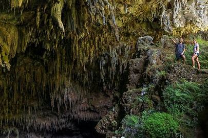
The track runs alongside the bed of the aptly-named Dry River, at the bottom of a steep-sided valley, with lush ferns and nikau growing on either side. After 1 km you’ll reach the bottom of the climb; beyond here the track is steep and rugged as it zig-zags up the steep hillside. After 25 min of climbing the cave entrance suddenly comes into view. The entrance is an upside-down crescent shape, with impressive stalactites hanging like teeth. A wooden platform extends out into the cave and panels provide information of the cave’s history and ecology. Prior to this platform being built you could descend right to the bottom of the cave, which drops away diagonally downward into the hillside. Do not venture off the wooden platform; the fragile cave formations and flora are easily damaged. Return the way you came. You will likely find the descent more challenging than the climb.
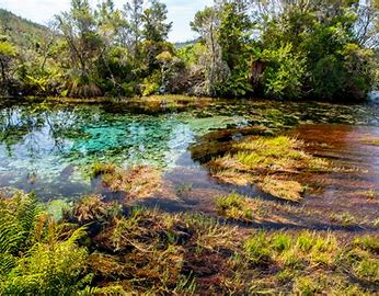
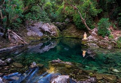
The walkway starts and finishes at the car park, where a sheltered area with Māori carvings has information panels that provide interesting details on the history, hydrology and ecology of the springs. The walkway can be walked in either direction. Though it is only 1 km in length, allow a little more time to admire the springs. The gravel walkway is wide and smooth. A few hundred metres from the car park a boardwalk crosses a shallow area of water flowing from Fish Creek Springs and then a bridge crosses the swift-flowing Fish Creek. Surrounding the walkway are impressive rimu, kahikatea and a particularly large mataī. The walkway reaches a viewing platform that overlooks Main Spring. The rippling surface of the water masks its true clarity, though the aqua blue sands and colourful aquatic vegetation can be seen at the bottom of the springs’ basin, which has a deceptive depth of nearly 7 m. Dancing Sands Spring, separated from Main Spring by a small island, is a short distance further and has its own, smaller viewing platform. The walkway heads back alongside Fish Creek, where a bridge crosses back to the start of the walkway next to the car park. The springs are considered wāhi tapu (sacred) by Māori. Their waters were traditionally used for ceremonies and healing processes, and a taniwha named Huriawa was said to guard them. To preserve their clarity, no contact is allowed to be made with the water that flows from the springs. Be respectful of this when you visit.
From Takaka, head north along Abel Tasman Drive. At Clifton, turn right onto Clifton Road. Follow the signposts to the The Grove Scenic Reserve, which is less than a kilometre up the road. There is a small parking area with a toilet. The walkway is a short loop less than a kilometre in length. From the car park, the walkway heads between limestone rocks that have been worn into interesting shapes. In the among the limestone are dense groves of nikau and huge northern rātā, providing a primeval feel. The walkway goes through a narrow slot in between huge of slabs of limestone, to a platform that overlooks the farmland around Clifton and further out across Golden Bay. The second half of the loop takes a slightly longer route back to the car park.
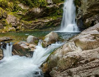
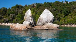
The track starts off along a farm road across the valley floor, before entering the bush alongside Wainui River. As the valley narrows, the track climbs up the hill slope above the true right of the river. There is steep drop to the river below, so it is important to keep children supervised here. Though narrow in a couple of parts, the track is mainly wide enough to allow people to pass in both directions. The bush is lush, with many ferns, vines and nikau. The track arrives at a suspension bridge which crosses to the true left. Below, Wainui River flows down among large granite boulders. The waterfall is located a few hundred metres beyond here.
Wainui Falls are 20 m high cascading falls. The track ends at a small concreted area that provides a great view of the waterfall. You can swim in the plunge pool, though there is a strong current flowing from the base of the waterfall. There are several pools further downstream that are good for swimming; you can access these by boulder-hopping down the river bed from the plunge pool.
Return the way you came.
Separation Point is accessed via Abel Tasman Coast Track.
From the car park at Tōtaranui there are two options for heading north along Coast Track; the high tide route and the low tide route. The high tide route, which is slightly longer, heads back from the beach along the road that leads into Tōtaranui (lined with plane trees planted by the Gibbs family in 1865). It then follows the gravel road that leads around the head of the inlet. The low tide route follows the road along the beachfront from the car park (or you can walk on the beach), and crosses the inlet. The low tide route is obviously only suitable when the tide is out. Look for the orange DOC triangle on the far side of the inlet to see where the track continues. The track enters native bush on the opposite side of the and follows its edge to connect with the high tide route.
The track climbs over a low saddle and descends through a lush gully featuring lots of nikau to the sandy beach of Anapai Bay, whihch is about 45 min from Tōtaranui. At Anapai Bay there is a DOC campsite and toilet.
From Anapai Bay, Coast Track heads off the beach and climbs past some impressively-tall rata trees, then sidles the hillside to avoid a rocky section of the coast between Anapai Bay and Anatakapau Bay. Openings in the trees allow views of the coast below. The track descends gently to Anatakapau Bay.
Anatakapau Bay is a half-kilometre stretch of golden sand beach. Towards the northern end of the bay next to the DOC campsite, Coast Track climbs off the beach and heads inland toward Whariwharangi Hut, while Separation Point track continues along the beach. At the northern end of Anatakapau Bay the track climbs over a small headland with a rocky cove that divides Anatakapau Bay from Mutton Cove. Continue along the beach of Mutton Cove to its northern end, where the track climbs the hillside to gain the ridge that leads to Separation Point.
Beyond the official track end a rough route climbs down to the rocky headland. On calm days this a good spot for lunch, and you’ll enjoy great views across Golden Bay to Farewell Spit and across Tasman Bay to D’Urville Island. There is a seal colony on the rocks at the water’s edge as well as numerous seabirds. Project Janszoon has a decoy gannet colony set on the headland with a loudspeaker playing gannet calls; this is to try and entice gannets to Separation Point by making it appear as a safe place to establish a breeding colony.
The easiest way to return to Tōtaranui is by retracing your steps. Alternatively, you can take a slightly longer route by turning right at the track junction just before Separation Point and following Separation Point Track along a narrow coastal ridge westwards to connect with Coast Track at the saddle above Whariwharangi Bay (you would come this way if you had started your walk at Wainui Bay). Turn left here and follow Coast Track as it descends gently back to Anatakapau Bay.
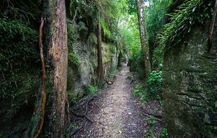
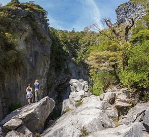
From the car park the track immediately enters beech forest, the trunks of which are sparsely-growing, giving the forest an airy feel. The track descends gently through the forest in a wide, flat gully. There are several karst ponds on the right side of the track along the way. After 1.5 km the gully narrows, and the track clambers over a jumbled mass of moss-covered marble boulders; this is the bed of the stream that was involved in the formation of Harwoods Hole long ago.
After 2.2 km you will reach the massive amphitheater that encircles the entrance to the Harwoods Hole. The track ends here, at a mass of boulders which you can climb over. The opening of the hole is about 50 metres across, but you cannot see down the shaft. Do not attempt to get close to the edge.
Return the way you came. Gorge Creek Lookout is a short deviation off the main track. The lookout gives impressive views over Gorge Creek valley and Takaka Valley, from a fractured marble outcrop.
The walkway follows the true left of Riuwaka River North Branch through lush native bush. The first half of the walkway to Crystal Pool has wheelchair access. Shortly afterwards the walkway ends at a viewing platform that overlooks the resurgence. A stairway leads down to the water edge. The steep hillside and overhanging bush can cause the walkway to be quite shaded and cool, even in summer. The water flowing from the cave is a frigid 9°C year-round.
The resurgence is known as Te Puna o Riuwaka by local Māori, Te Ātiawa and Ngāti Rārua, and is considered wāhi tapu (sacred). Traditionally, Māori would not eat or swim at the site, and the waters were considered to have powerful healing properties. Please be respectful of this when you visit.
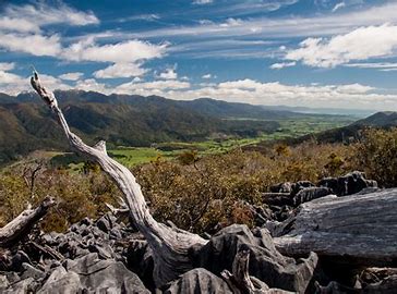
The beginning of the walkway follows a 4WD road. The road heads to the left, but continue to the right (following the signposts), which takes a more direct route uphill. After 600 m the walkway rejoins the 4WD and curves around to the west to overlook Takaka Valley. Take a short deviation up the road to a radio tower, situated atop a knob at 950 m elevation. Here you will enjoy magnificent views of the upper Takaka Valley, Golden Bay and the Tasman Mountains in Kahurangi National Park.
The walkway continues down around the high point, clambering around and over coarse marble through dense scrub. A little further on you will enter a section of native forest, and then reach a link track that heads back to the 4WD road (which you can take to get back to the car park). Otherwise continue along the walkway, as it heads east through karst, scrub and beech forest, and loops back to the 4WD road after 2 km.
The walkway is well signposted the whole way around. It does not allow for fast travel; pay attention to where you place your feet, as the oddly-shaped rock formations and uneven track can easily cause falls and twisted ankles.
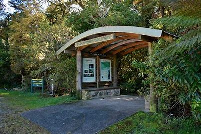
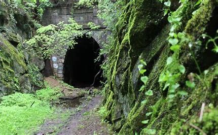
The walkway is located at Kawatiri Junction, which is the junction of State Highway 6 and State Highway 63, 77 km southwest of Nelson and 35 km northeast of Murchison. There is a car park on the left side of the road where the historic Kawatiri Station platform remains. The platform now hosts information panels that provide details on the history of the rail line and the Pikomanu settlement that used to exist nearby.
The walkway crosses Hope River over a pedestrian footbridge that utilises the old rail bridge piers. The tunnel is immediately after the bridge. You can walk the tunnel without a torch, though it would be handy to avoid the puddles that can sometimes pool. At the northern tunnel portal the old bridge piers can be seen in Hope River bed. The walkway climbs a staircase and passes through beech forest around Woodhen Bend in Hope River, and returns back to the southern tunnel portal to complete the loop. Just before you return to the southern tunnel portal you will notice a small hollow cut into the rock on the hill slope on the left; this was used as an explosives store by tunnel construction workers. Cross the bridge back to the car park to finish the the walk.
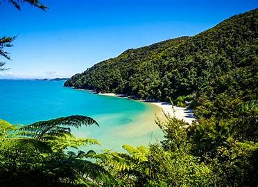
he Abel Tasman Coastal Track follows a pristine coastline of extraordinary beauty. Clear, turquoise bays, abundant bird and sea life, and fresh, clean air surround you as you walk under the shady canopy of lush native forest. Birdsong rings through the treetops above, only interrupted by the call of the occasional small waterfall nestled in the midst of the park.
You can walk into the Park from the seaside village of Marahau, Canaan Downs (at the top of Takaka Hill) or from the picturesque Wainui Bay. Or, you can be dropped off at various points along the track by sea, paddle in by kayak, or be flown in to the airstrip in Awaroa Bay by plane or helicopter. Several water transport operators are based in Kaiteriteri and Marahau at the southern end of the Park, and many offer combo options so you can cruise, walk or kayak sections of the park at your own pace.
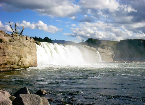
Tucked away in the heart of New Zealand's South Island, Maruia Falls is a hidden gem that beckons to those in search of natural beauty and tranquillity. Nestled amidst lush rainforests and pristine landscapes, this captivating waterfall is a testament to the country's untouched wilderness.
As you approach Maruia Falls, you'll be greeted by the soothing sounds of rushing water and the sight of a picturesque cascade tumbling over moss-covered rocks. The falls, framed by dense native bush, create an enchanting scene that seems straight out of a fairy tale. It's a place where time slows down, and the beauty of nature takes centre stage.
For adventurers and nature enthusiasts, Maruia Falls offers more than just a scenic view. The surrounding area boasts walking trails that wind through ancient forests, offering opportunities for exploration and birdwatching. The Maruia River, with its crystal-clear waters, invites visitors to dip their toes or take a refreshing swim in the natural pools.
Maruia Falls is not just a destination for sightseers; it's a place to reconnect with the rhythms of nature. Whether you're enjoying a leisurely picnic along the riverbank, meditating to the symphony of the falls, or capturing the moment with your camera, this hidden oasis promises an escape from the ordinary and a chance to immerse yourself in the timeless beauty of New Zealand's wilderness.
In the embrace of Maruia Falls, you'll find a serene haven where the stresses of modern life fade away, leaving you with a profound sense of peace and wonder. It's a place that invites you to unwind, rejuvenate, and discover the serene magic of New Zealand's natural wonders. Visit Maruia Falls and let the beauty of this cascading spectacle leave you awestruck and inspired.
Nestled in the heart of New Zealand's North Island, Lake Rotorua is a mesmerizing natural wonder that captures the essence of Aotearoa's diverse landscapes. This pristine lake, surrounded by lush forests and rolling hills, is a testament to the country's breathtaking beauty.
Beyond its picturesque allure, Lake Rotorua is renowned for its unique geothermal features. Along its shores, bubbling hot springs, erupting geysers, and mud pools punctuate the landscape, creating a surreal and otherworldly atmosphere. The soothing scent of sulfur hangs in the air, a reminder of the Earth's simmering power beneath.
For those seeking relaxation and rejuvenation, Lake Rotorua's hot springs and spas offer a therapeutic experience like no other. Immerse yourself in the healing waters and let your cares melt away amid the tranquil surroundings.
The lake also beckons adventurers and nature enthusiasts with a myriad of recreational opportunities. Kayak across its serene waters, hike through the nearby Redwood Forest or embark on a scenic boat tour to fully immerse yourself in this natural paradise.
Lake Rotorua is more than a destination; it's an encounter with the raw forces of nature, a serene escape, and an exploration of geothermal marvels. Whether you come for the breathtaking views, the healing waters, or the adventure, Lake Rotorua promises an unforgettable experience in the heart of New Zealand's geothermal wonderland.