Whangarei
17.89°C

Whangarei
17.89°C
Waitakere City
16.98°C
Manukau City
17.11°C

Papakura
24.46°C
Hauraki
17.26°C

Waikato
17.67°C
Matamata
18.46°C
Hamilton
17.51°C
Otorohanga
18.52°C
Rotorua
16.6°C
Taupo
15.44°C
Tauranga
19.27°C
Kawerau
18.6°C
Whakatane
19.64°C
Gisborne
15.51°C
New Plymouth
16.98°C

Stratford
8.97°C
Ruapehu
14°C
Wanganui
17°C
Palmerston North
16.41°C
Wairoa
19.19°C
Hastings
18.84°C
Napier
18.49°C
Masterton
15.49°C
Carterton
15.66°C
Porirua
15.99°C
Lower Hutt
16.45°C

Wellington
15.79°C

Tasman
9.35°C
Nelson
16.27°C
Marlborough
3.22°C
Kaikoura
15.48°C
Christchurch
12.59°C
Ashburton
12.52°C
Timaru
13.37°C
Waitaki
11.32°C
Waimate
13.08°C

Queenstown
12.38°C
Dunedin
14.33°C
Southland
9.98°C
Gore
11.31°C
Invercargill
12.06°C
Blenheim
14.73°C
Te Anau
27.35°C
Wanaka
11.17°C
Kaikoura
13.38°C
Stratford
13.54°C
Upper Hutt
15.9°C
About
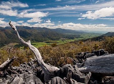
The beginning of the walkway follows a 4WD road. The road heads to the left, but continue to the right (following the signposts), which takes a more direct route uphill. After 600 m the walkway rejoins the 4WD and curves around to the west to overlook Takaka Valley. Take a short deviation up the road to a radio tower, situated atop a knob at 950 m elevation. Here you will enjoy magnificent views of the upper Takaka Valley, Golden Bay and the Tasman Mountains in Kahurangi National Park.
The walkway continues down around the high point, clambering around and over coarse marble through dense scrub. A little further on you will enter a section of native forest, and then reach a link track that heads back to the 4WD road (which you can take to get back to the car park). Otherwise continue along the walkway, as it heads east through karst, scrub and beech forest, and loops back to the 4WD road after 2 km.
The walkway is well signposted the whole way around. It does not allow for fast travel; pay attention to where you place your feet, as the oddly-shaped rock formations and uneven track can easily cause falls and twisted ankles.


