Whangarei
17.89°C

Whangarei
17.89°C
Waitakere City
16.98°C
Manukau City
17.11°C

Papakura
24.46°C
Hauraki
17.26°C

Waikato
17.67°C
Matamata
18.46°C
Hamilton
17.51°C
Otorohanga
18.52°C
Rotorua
16.6°C
Taupo
15.44°C
Tauranga
19.27°C
Kawerau
18.6°C
Whakatane
19.64°C
Gisborne
15.51°C
New Plymouth
16.98°C

Stratford
8.97°C
Ruapehu
14°C
Wanganui
17°C
Palmerston North
16.41°C
Wairoa
19.19°C
Hastings
18.84°C
Napier
18.49°C
Masterton
15.49°C
Carterton
15.66°C
Porirua
15.99°C
Lower Hutt
16.45°C

Wellington
15.79°C

Tasman
9.35°C
Nelson
16.27°C
Marlborough
3.22°C
Kaikoura
15.48°C
Christchurch
12.59°C
Ashburton
12.52°C
Timaru
13.37°C
Waitaki
11.32°C
Waimate
13.08°C

Queenstown
12.38°C
Dunedin
14.33°C
Southland
9.98°C
Gore
11.31°C
Invercargill
12.06°C
Blenheim
14.73°C
Te Anau
27.35°C
Wanaka
11.17°C
Kaikoura
13.38°C
Stratford
13.54°C
Upper Hutt
15.9°C
About


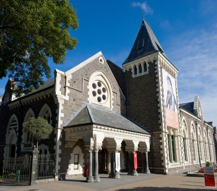
The Canterbury Museum is a museum located in the central city of Christchurch, New Zealand, in the city's Cultural Precinct. The museum was established in 1867 with Julius von Haast – whose collection formed its core – as its first director. The building is registered as a "Historic Place – Category I " by Heritage New Zealand.
Learn about the natural history of Canterbury, the people who have made their homes here and our connection to Antarctica.
The Māori galleries display treasures and tools from our region’s first people. The Christchurch Street and Victorian Museum recreate the nineteenth-century city. At the world-famous kiwiana icon, Fred & Myrtle’s Pāua Shell House see more than 1,000 pāua shells, the most you’ll find in any one place. Learn about the heroic explorers of the icy continent and see objects from the Museum’s internationally significant Antarctic collection.
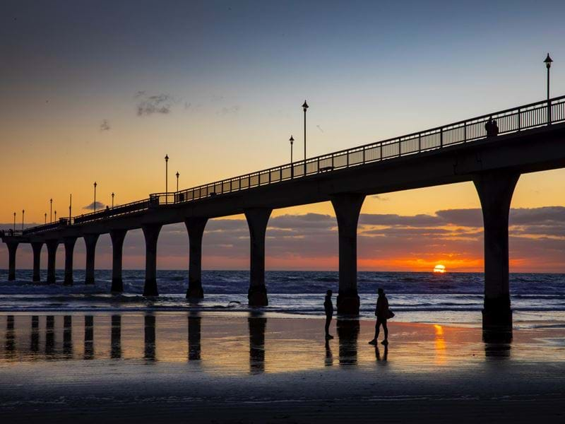
New Brighton has seen two piers in its time. The original one was of wooden construction, opened on 18 January 1894 and was pulled down October 1965. This pier was 700 feet (210 m) long. At one stage the pier had a “penny arcade” full of games and amusements along the traditional British style of pier. Also a popular nightclub called the Shoreline was situated at the shore end of the pier where the library now sits.
In the early days the Pier and Foreshore Society tried to save the original pier from being demolished and this group continued on to lobbying for a new pier to be built.
When $2 million was raised, Christchurch City Council matched the amount and a new pier was designed using concrete.
Built in the same location as the old one, it was opened in November 1997; it is 300m (980 ft.) long and makes it the longest pier in the Australasia.
It was damaged in the February 2011 earthquake repairs to the pier were completed in 2018, costing around $9 million.
A modern Library with excellent facilities sits at the start of the pier, with seating placed along large windows looking out to the sea. This is a great place to sit and relax whilst you enjoy a good read. In the same building there is also a bar and restaurant called the Salt on the Pier.
Out in front of the Library “New Brighton Mall Side” there is a Commemorative plaque with a large mounted surf board dedicated to "The spirit of surfing" Duke Paoa Kahanamoku.
On the 24th February 1915 the world-renowned Hawaiian surf board rider and Olympic Gold Medal swimmer, Duke Paoa Kahanamoku gave his first New Zealand demonstration of surf riding. Quite an honour for the seaside suburb in the day as the Duke was very highly regarded.
The pier is one of the many Christchurch tourist attractions and sees plenty of visitors especially in good weather.
Along with the Pier there is plenty on offer. The beach has a Surf Life Saving Club operating swim patrols over the summer months, a Seaside Shopping Mall with a large Supermarket, the famous New Brighton Whale Pool and Playground and a Saturday Market.
It also has a selection of Bars, Cafes and Accommodation on offer.
All this combined together makes New Brighton a great place to visit and chill out in Christchurch.
New Brighton Pier is also the venue for the annual Guy Fawkes fireworks display held on the 5th November every year, Thousands of people gather on the beach to watch.
Fishing is very popular on the pier. However please keep in mind there are some restrictions to where you can fish or when as the number of people fishing were disrupting the pier for other visitors.
The main access to the Bridle Path and nearby tracks is from the gondola car park in Heathcote, Barnett Park car park, the Summit Road, and Evans Pass Road. Some car parking is available at either end of the closed section of Summit Road.
Be prepared this is a hill and you will be in for a good workout as it is a steep walk however once at the top views from the summit are well worth the effort.
As you walk up you will see what remains of Castle Rock to the west and the massive boulders strewn down the hillside in the Christchurch earthquakes. There are a number of memorial seats on the way up and a stone shelter at the top to commemorate the pioneer women of Canterbury.
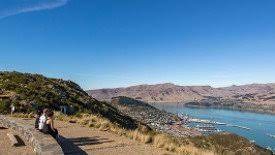
At the Summit Road take on the panoramic view over Lyttelton Harbour with Banks Peninsula's highest peak, Mt Herbert (Te Ahu Pataki) rising above the small settlement of Diamond Harbour that many people commute to Christchurch from.
You want to head back the same way you came up or follow the Crater Rim Walkway in either direction or continue on to Lyttelton.
The track to Lyttelton descends steeply before joining up with Bridle Path Road. If it is a Saturday take time to visit the Lyttelton Farmers Market. Lyttelton is a port town unique in its own way and will one day become a very popular spot as they open up the Warf to the public again.
Bus 28 will take you back through the tunnel to Heathcote near the Bridle Path car park.
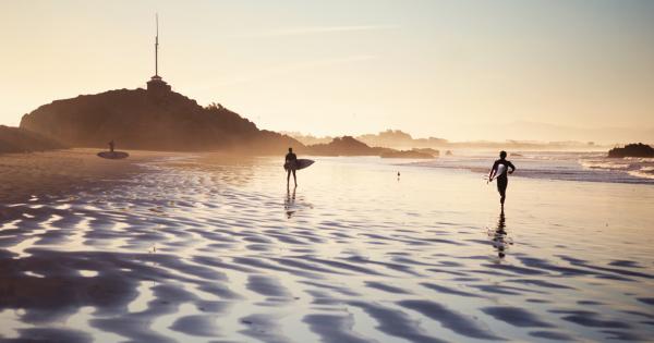
Close to the township of Sumner this Christchurch beach that continues onto Scarborough beach by a 1.25 km promenade starting at Cave Rock. Sumner beach also has the nearby outlet of the Avon Heathcote Estuary. Note although it is possible to reach the South Shore side of the outlet from Sumner beach hidden strong rips and undertows at the mouth can be a danger to swimmers.
The Sumner Bar is a sand bar where the estuary meets the sea and had a reputation in the early days as being dangerous for shipping to cross.
There is reasonable fishing at the mouth of the estuary and you will see plenty of people trying their luck if conditions are right.
Sumner beach itself has a wide sandy area and is popular with families as it has a gentle slopping tidal area “always swim between the flags”.
Located on the beach and across the road are cafes etc. with some parking available.
Surfers generally surf on the other side of Cave Rock which has a swell suitable for learners and intermediates, although an off shore wind can produce something for the more experienced surfer (further up at Scarborough beach under the right conditions can produce a very nice wave as well).
If you want to explore Cave Rock (at low tide) from the seaward side of Cave Rock it is an easy walk through the short tidal cave and you come out on the other side near the foot of a walking ramp onto the promenade. Cave Rock itself is an easy climb for someone sure of foot and a plaque on the tower at the top is dedicated to Captain of the Sumner Lifeboat, Joseph Day, who saved many lives between 1867 and 1880.
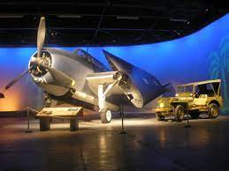
The Air Force Museum of New Zealand is the national museum for the Royal New Zealand Air Force (RNZAF) and New Zealand military aviation, and stands on the site of the former air base at Wigram, Christchurch.
The Air Force Museum of New Zealand had its origins in the RNZAF Historical Centre, established at RNZAF Base Wigram in 1976. This was a small-scale, part-time venture, until 1981 when a formal Air Force Order established the RNZAF Museum as an official Air Force unit, staffed by uniformed Air Force personnel.
The Museum initially occupied part of ‘No. 7’ Hangar (since demolished) for all of its activities, including displays, but by 1982, it became apparent that new purpose-built premises would be required. A major fundraising campaign began and many organisations and individuals contributed significantly to the establishment of the facility we have today.
The new building was attached to the existing ‘No. 1’ Hangar (now the Aircraft Hall) on Harvard Avenue, and was officially opened on 1 April 1987 as part of the celebrations for the 50th anniversary of the RNZAF. The Museum continued to occupy No. 7 Hangar for its technical and restoration work until moving into ‘No. 2’ Hangar in 1994, just before RNZAF Base Wigram closed in 1995.
The first major revamp of the Museum’s galleries occurred in 2008, when the traditional ‘History Gallery’ was completely redesigned and the present Horizon to Horizon gallery opened. Another landmark change occurred in 2009, when the Museum Trust Board introduced free admission. This decision was made in recognition of the Museum’s national significance, and a desire to make the RNZAF story as accessible as possible.
In January 2013 the Museum Trust Board’s new $16 million, 6,500m² extension was completed, the first major building project since the Museum’s opening. As well as housing the technical and exhibitions teams and Reserve Collection, the space known as the Thérèse Angelo Wing will ultimately serve as a brand new display hall. Conference and events operations will continue until approximately 2019 when a new convention centre is expected to open in Christchurch.
Today, the Museum is situated on 37 hectares of land and is accommodated in six buildings onsite with a total of approximately 5,000m2 of display area and 14,000m2 of storage and workshop space. It is a world class cultural institution, employing a team of over 30 professional staff, and attracting around 150,000 visitors per year.
Halswell Quarry Christchurch Walks
Duration of walk: Various walks ranging from 5 - 40 minutes with the opportunity to combine walks its up to the individual to pick the route and pathways the quarry has picnic areas and includes walkways around the lakes and sister city gardens great asset for Christchurch.
Start location: All walks can be accessed from the car park off Kennedys Bush Road we found the first stage walking up to a viewing platform to be the most challenging once past this it is fairly easy.
Although if you haven’t been before in some parts it is easy to walk off the track and end up taking shorter routes than you were looking to do.
You won't get lost but the track signage is very minimal so you can sometimes be walking over the same ground but its all good especially on a nice day.
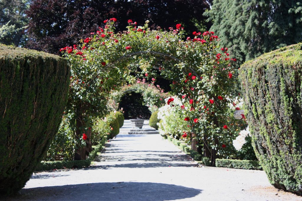
Very unique 60.4 hectare park in that you have six sister city gardens to walk through and a botanical collection well worth a visit in the spring to see the blossom’s out giving a spectacular display and great photo opportunities.
Halswell Quarry is a great place for the whole family and includes a dog exercise area. The area is unfenced so dogs must remain under control at all times but may be allowed off-leash.
So its not just a walking track but a great place to spend part of a nice day.
Halswell is named after Edmund Storr Halswell a government officer and member of the management commission of the Canterbury Association.
This Christchurch quarry played a significant role in the development of the Christchurch region. It ceased production in 1990 after 130 years of quarrying and was believed to be the oldest continually operating quarry in Australasia.
Halswell stone is a distinctive blue-grey stone and was used in many of the city's more prominent buildings which includes the Canterbury Museum.
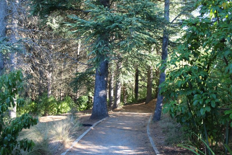
Spend a day in the outdoors cycling, walking, or running. Enjoy the peace and listen to native birdcall.
Victoria Park on the outskirts of Christchurch offers a wealth of outdoor activities from the gentlest of walks to thrilling mountain bike tracks.
Panoramic views of the city, the Canterbury Plains, the Southern Alps, and Pegasus Bay add a picturesque element to any visit to the park and visitors should take time to enjoy the views on a sunny day.
The park was first planted in the early 1880s, and it was officially opened in 1897 to mark the Diamond Jubilee of Queen Victoria, after whom the park is named.
Since then, continued planting has brought native birds back to the area including fantails, silvereyes, and bellbirds, which can all be heard calling from the trees. Many of the plantings are native to New Zealand such as the kauri tree, while other more exotic plants grow on the western slopes of the park where the climate is warmer.
For families the park offers playgrounds and picnic areas, while more serious outdoor adventurers can enjoy the range of tracks. Some of the tracks are suitable for pushchairs and wheelchairs while others are more suited to experience walkers and cyclists.
There is also a permanent orienteering course laid out around the park for visitors who wish to challenge their path finding skills. Map packs can be purchased from the city council's service centre in Beckenham.
Park gates open at 7.30am daily. Gates close: January to March: 9.00pm / April:7.00 pm / May: 7.00 pm / June to August: 6.00 pm / September & October: 7.00 pm / November & December: 9.00 pm
Bottle Lake Forest Christchurch an outdoor playground that covers 800 hectares for all to enjoy. Another wonderful asset for the East side of Christchurch, well worth visiting for some outdoor exercise.
In this reserve there are numerous tracks for walking or riding a mountain bike. Two of the most popular walking tracks are marked by green & blue markers. "please note there are a number of markers missing".
Both green & blue tracks start from the car park where there is a map "map can be out of date however".
The green track is a short loop track that winds around the 1000-hectare pine forest. The blue track is a larger loop that takes you around the forest and onto Spencer Park if desired.
Other tracks will link to the Southern Pegasus Bay track and the coastline. The forest is crisscrossed with shingle roads used when Rangers or when forestry operations are happening.
All these roads are sign posted and can be found on the maps you can walk these as an alternative to the tracks.
There is also a dump within the forest that was used for dumping materials from the earthquakes. This is serviced by a sealed road and the dump itself is fenced off. Signage and maps are due for an update so keep track of landmarks as it is easy to get a little disorientated.
Watch out when crossing mountain bike tracks when walking.
Popular Christchurch walk and cycle this is a shared track with plenty of space to accommodate both bikes, walkers and the occasional 4WD.
Entry via Rapaki Road takes you up to the top of Witch Hill on the Port Hills over a mixed surface track that ends up on the Summit Road.
Although regarded as an easy walk this is still a good work out and if your not used to walking up hill it's one of those walks you may well say are we there yet!.
However once up at the top you are rewarded with stunning Port Hills and then city, beach and ocean views and the sense of accomplishment having completed.
At the top of the track there is access to a number of walks to continue exploring the Port Hills and you can take an alternative way down.
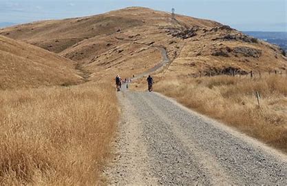
For something a little more intense, head a little further up Kennedy’s Bush road to where Kennedy’s Bush Track begins. Leading up towards Summit road, the track takes you through private land so be sure to leave your four-legged friends at home as you get up close and personal to New Zealand wildlife and livestock. Depending on your fitness levels, it may take about an hour each way showcasing similar stunning Christchurch views. It’s mostly uphill with little flat walking so if you’re keen to get your heart rate up be sure to give Kennedy’s Bush a crack.
This track is closed from April to September for Lambing season.
This track offers spectacular and panoramic views of Lyttelton Harbour and the eastern coastal line. From the Taylors Mistake carpark turn right and make your way behind the beach to the start of the Pilgrims Way Coastal Track. Climbing above the sea, the track offers views of places where old cave dwellings were built into the hillside, as well as views down to the rocks and sea below. Passing Boulder Bay and giving access to two of the first gun platforms, the track climbs up to the headland and the historic Godley Head coastal defence battery.
Here there are dramatic views including views:
The gun emplacements have interpretative graffiti which celebrates the role of the Women's Auxiliary Army Corp in running the place during WWII. It also has a lighted underground magazine to explore, as well as interpretation panels telling the history of the site. From here the Godley Head Gun Emplacements Track carries on around the nose of the headland, past the historic military buildings. This area includes the Battery Observation posts located at the entrance to Lyttelton Harbour. It ends at the public carpark at Godley Head. There are toilets here.
From the carpark, the track climbs high above Breeze Bay. From here there are views of Lyttelton Harbour and Banks Peninsula. The track then drops back down to Breeze Col. From Breeze Col follow the Black Rock track down for 20 minutes to the Pilgrims Way Coastal Track. Turn left there to walk back to Taylors Mistake Beach and carpark.
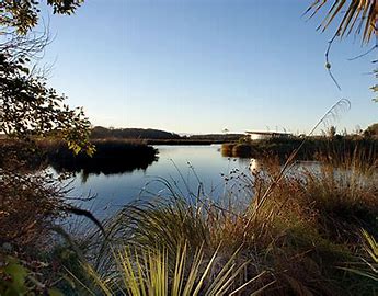
Travis Wetland is located in north-east Christchurch, close to sea-level, and is typical of pre-European Christchurch and Canterbury plains swamp lands.
1600 years ago it was an estuary similar to the Avon/Heathcote Estuary of today. A sandbar gradually shut out the sea, decreasing salinity and allowing wetland plants to take over from saltmarsh species.
Travis is the largest wetland in Christchurch with an area of 56.5 hectares, and is unique in the fact that it is situated in an urban area. Bounded by Mairehau, Frosts, and Travis Roads, this area is Christchurch’s last major piece of freshwater wetland. When you consider that Christchurch was built from a swamp, these remaining wetlands become a very important part of our history and heritage.
Travis Wetlands were one of the mahinga kai (traditional resource gathering areas) and used by Waitaha from about 900AD, Kati Mamoe from about 1600, and by Ngai Tahu from about 1650. Queen Elizabeth II Park now occupies the land (known as Oruapaeroa) that was the residential area for the families of Ngai Tahu who harvested these wetlands. Eel, fish, kereru, raupo seeds, and other wildlife were in abundant supply. Harakeke was used for weaving baskets, clothing, and roofing, and raupo was used for thatch. In the mid 19th century the whare of Oruapaeroa were still standing but were burnt down in 1862 when a European settler gained crown grant of the land. Māori had requested that this ancient pa site be excluded when Kemp's Purchase of 1848 was drawn up, but this did not happen.
Only a decade ago, these wetlands were grazed by cattle and looked like becoming yet another housing development. The Travis Wetland Trust lobbied the Christchurch City Council to step in and buy the land which they did in 1996.
Travis Wetland is an important site for local and regional conservation of wetland plants. Among the plants here are manuka, the tall baumea reed, a spider orchid, and other small herbaceous plants. These survivors nestle within the predominant vegetation of rushes, sedges, grasses, herbs, New Zealand flax, raupo, and ferns. Some of the native plants here were thought to be locally extinct.
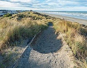
Take a stroll with your doggo friend along our city’s eastern coast cruising a large, coastal trail in the dune crest and forests of New Brighton. Stretching between Southshore Spit to Spencer Park Surf Club, you can start the Southern Pegasus Bay Track at either end, or for a shorter walk, start at Broad Park. Enjoy the tranquility of Spencer Park and Bottle Lake Forests and the impressive views of the Pacific Ocean when following the crest of the dune. There are varying difficulty levels on this extensive multi-track, so there’s something for everyone!
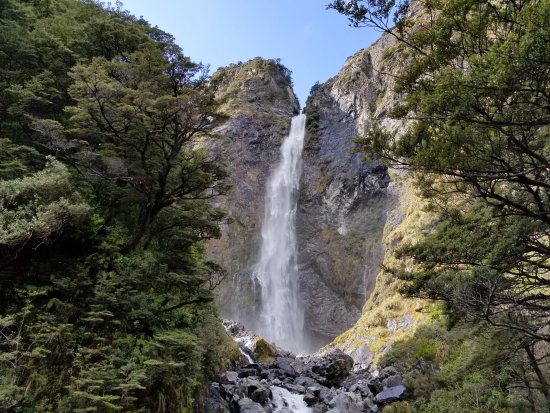
Although the top of the Devil's Punchbowl Falls can be seen from the main road, the walk to the base of the waterfall is well worth the trip at any time of year.
Follow the path as it crosses the Bealey River, via a foot bridge. At the second bridge take time to pause for a good view of the waterfall, then climb the series of steps that travel up 150 metres, to the viewing platform.
The return trip follows the same path.