Whangarei
17.89°C

Whangarei
17.89°C
Waitakere City
16.98°C
Manukau City
17.11°C

Papakura
24.46°C
Hauraki
17.26°C

Waikato
17.67°C
Matamata
18.46°C
Hamilton
17.51°C
Otorohanga
18.52°C
Rotorua
16.6°C
Taupo
15.44°C
Tauranga
19.27°C
Kawerau
18.6°C
Whakatane
19.64°C
Gisborne
15.51°C
New Plymouth
16.98°C

Stratford
8.97°C
Ruapehu
14°C
Wanganui
17°C
Palmerston North
16.41°C
Wairoa
19.19°C
Hastings
18.84°C
Napier
18.49°C
Masterton
15.49°C
Carterton
15.66°C
Porirua
15.99°C
Lower Hutt
16.45°C

Wellington
15.79°C

Tasman
9.35°C
Nelson
16.27°C
Marlborough
3.22°C
Kaikoura
15.48°C
Christchurch
12.59°C
Ashburton
12.52°C
Timaru
13.37°C
Waitaki
11.32°C
Waimate
13.08°C

Queenstown
12.38°C
Dunedin
14.33°C
Southland
9.98°C
Gore
11.31°C
Invercargill
12.06°C
Blenheim
14.73°C
Te Anau
27.35°C
Wanaka
11.17°C
Kaikoura
13.38°C
Stratford
13.54°C
Upper Hutt
15.9°C
About
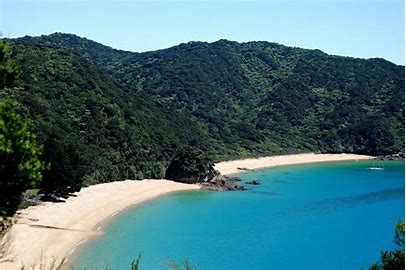
Separation Point is accessed via Abel Tasman Coast Track.
From the car park at Tōtaranui there are two options for heading north along Coast Track; the high tide route and the low tide route. The high tide route, which is slightly longer, heads back from the beach along the road that leads into Tōtaranui (lined with plane trees planted by the Gibbs family in 1865). It then follows the gravel road that leads around the head of the inlet. The low tide route follows the road along the beachfront from the car park (or you can walk on the beach), and crosses the inlet. The low tide route is obviously only suitable when the tide is out. Look for the orange DOC triangle on the far side of the inlet to see where the track continues. The track enters native bush on the opposite side of the and follows its edge to connect with the high tide route.
The track climbs over a low saddle and descends through a lush gully featuring lots of nikau to the sandy beach of Anapai Bay, whihch is about 45 min from Tōtaranui. At Anapai Bay there is a DOC campsite and toilet.
From Anapai Bay, Coast Track heads off the beach and climbs past some impressively-tall rata trees, then sidles the hillside to avoid a rocky section of the coast between Anapai Bay and Anatakapau Bay. Openings in the trees allow views of the coast below. The track descends gently to Anatakapau Bay.
Anatakapau Bay is a half-kilometre stretch of golden sand beach. Towards the northern end of the bay next to the DOC campsite, Coast Track climbs off the beach and heads inland toward Whariwharangi Hut, while Separation Point track continues along the beach. At the northern end of Anatakapau Bay the track climbs over a small headland with a rocky cove that divides Anatakapau Bay from Mutton Cove. Continue along the beach of Mutton Cove to its northern end, where the track climbs the hillside to gain the ridge that leads to Separation Point.
Beyond the official track end a rough route climbs down to the rocky headland. On calm days this a good spot for lunch, and you’ll enjoy great views across Golden Bay to Farewell Spit and across Tasman Bay to D’Urville Island. There is a seal colony on the rocks at the water’s edge as well as numerous seabirds. Project Janszoon has a decoy gannet colony set on the headland with a loudspeaker playing gannet calls; this is to try and entice gannets to Separation Point by making it appear as a safe place to establish a breeding colony.
The easiest way to return to Tōtaranui is by retracing your steps. Alternatively, you can take a slightly longer route by turning right at the track junction just before Separation Point and following Separation Point Track along a narrow coastal ridge westwards to connect with Coast Track at the saddle above Whariwharangi Bay (you would come this way if you had started your walk at Wainui Bay). Turn left here and follow Coast Track as it descends gently back to Anatakapau Bay.


