Whangarei
17.89°C

Whangarei
17.89°C
Waitakere City
16.98°C
Manukau City
17.11°C

Papakura
24.46°C
Hauraki
17.26°C

Waikato
17.67°C
Matamata
18.46°C
Hamilton
17.51°C
Otorohanga
18.52°C
Rotorua
16.6°C
Taupo
15.44°C
Tauranga
19.27°C
Kawerau
18.6°C
Whakatane
19.64°C
Gisborne
15.51°C
New Plymouth
16.98°C

Stratford
8.97°C
Ruapehu
14°C
Wanganui
17°C
Palmerston North
16.41°C
Wairoa
19.19°C
Hastings
18.84°C
Napier
18.49°C
Masterton
15.49°C
Carterton
15.66°C
Porirua
15.99°C
Lower Hutt
16.45°C

Wellington
15.79°C

Tasman
9.35°C
Nelson
16.27°C
Marlborough
3.22°C
Kaikoura
15.48°C
Christchurch
12.59°C
Ashburton
12.52°C
Timaru
13.37°C
Waitaki
11.32°C
Waimate
13.08°C

Queenstown
12.38°C
Dunedin
14.33°C
Southland
9.98°C
Gore
11.31°C
Invercargill
12.06°C
Blenheim
14.73°C
Te Anau
27.35°C
Wanaka
11.17°C
Kaikoura
13.38°C
Stratford
13.54°C
Upper Hutt
15.9°C
About
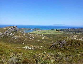
From the car park, Kaituna Track follows an old forestry road along a spur through regenerating mixed podocarp forest. The track has a gentle uphill gradient most of the way. Occasional gaps in the trees allow glimpses towards the coast, and Knuckle Hill can be see ahead. After 4 km you will reach the turnoff to Knuckle Hill. If you’re riding you’ll have to leave your bike here as the remaining distance is unrideable. The track emerges into pakihi scrub of manuka and tussock, with sandy granite rocks underfoot. At this point the track steepens as you climb the remaining 150 vertical metres to the trig at the summit. The 506 m elevation summit offers stunning views; Knuckle Hill is the only sufficiently-prominent location able to provide views of the entire Whanganui Inlet. You will also enjoy views of western side of Burnett Range, the forested hill country southwest between the coast and Wakamarama Range, and on clear days you may be able to see Kahurangi Point Lighthouse. Return from the summit the way you came. Once back at the Kaituna Track, turn right to head back to the car park. Otherwise, Kaituna Track heads left and continues for a further 14 km to Aorere Valley.


