Whangarei
17.89°C

Whangarei
17.89°C
Waitakere City
16.98°C
Manukau City
17.11°C

Papakura
24.46°C
Hauraki
17.26°C

Waikato
17.67°C
Matamata
18.46°C
Hamilton
17.51°C
Otorohanga
18.52°C
Rotorua
16.6°C
Taupo
15.44°C
Tauranga
19.27°C
Kawerau
18.6°C
Whakatane
19.64°C
Gisborne
15.51°C
New Plymouth
16.98°C

Stratford
8.97°C
Ruapehu
14°C
Wanganui
17°C
Palmerston North
16.41°C
Wairoa
19.19°C
Hastings
18.84°C
Napier
18.49°C
Masterton
15.49°C
Carterton
15.66°C
Porirua
15.99°C
Lower Hutt
16.45°C

Wellington
15.79°C

Tasman
9.35°C
Nelson
16.27°C
Marlborough
3.22°C
Kaikoura
15.48°C
Christchurch
12.59°C
Ashburton
12.52°C
Timaru
13.37°C
Waitaki
11.32°C
Waimate
13.08°C

Queenstown
12.38°C
Dunedin
14.33°C
Southland
9.98°C
Gore
11.31°C
Invercargill
12.06°C
Blenheim
14.73°C
Te Anau
27.35°C
Wanaka
11.17°C
Kaikoura
13.38°C
Stratford
13.54°C
Upper Hutt
15.9°C


Let us know about yourself so we can better match suggestions for you.
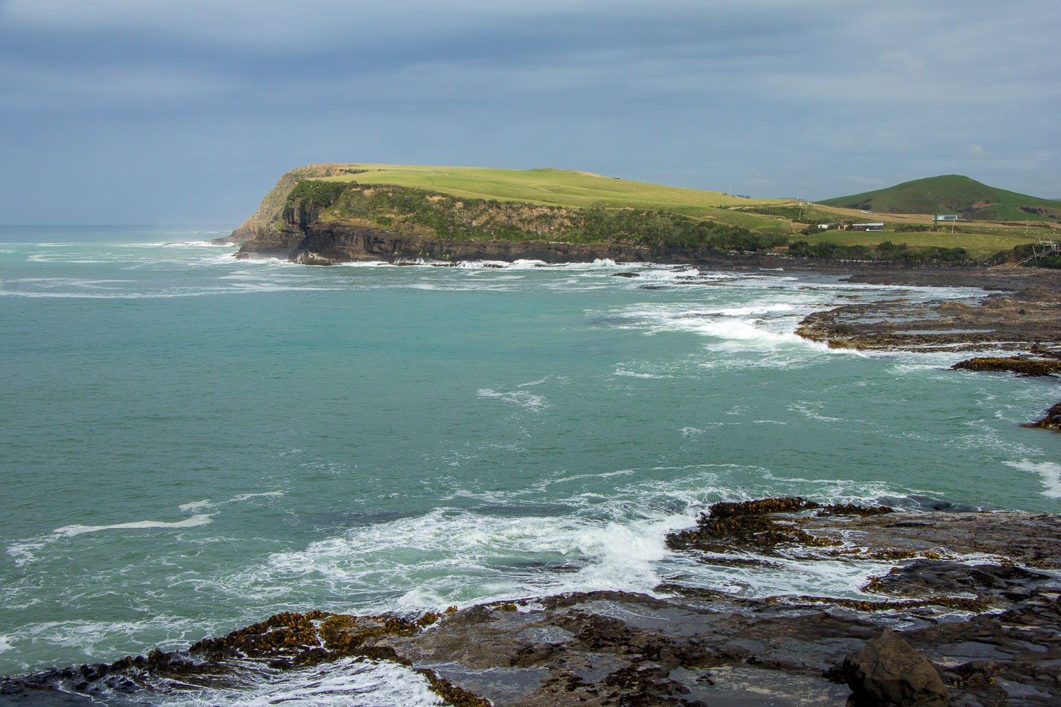
A rugged and wild coastline next to a lovely beach provides the setting for a Petrified Forest, a Living forest, and a chance to see some amazing wildlife.
Curio Bay is of international significance for its Petrified Forest dating back to the Jurassic period. The tree fossils you see here, similar to Kauri and Matai, are approximately 170 million years old. The forest was alive when New Zealand was part of Gondwanaland.
Curio Bay’s Petrified Forest is best viewed at low tide from the viewing platform. Please do not damage or remove any fossils and to protect the wildlife, no dogs are permitted in the area. You can also walk through the Living Forest walkway and see how the Petrified Forest may have looked millions of years ago. This is a special occurrence in the world to see a fossil forest so close to its living counterpart.
You may also see protected Yellow-eyed Penguins at Curio Bay in the late afternoon as they come ashore after a day at sea. Please be sure to read the Department of Conservation information on these protected birds.
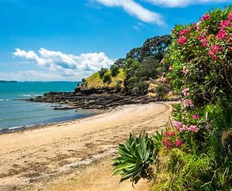
From Curio Bay, you could take a short walk to Porpoise Bay a beautiful beach for walking, and swimming, and where you may see the endangered Hector’s dolphins playing in the surf during the summer months.
The recently opened Curio Scape has a café and interactive museum.
Walk from the car park to Petrified Forest – 5 minutes.
Living Forest Walkway - 15 minutes return.
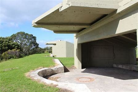
The grounds of Fort Takapuna is on a commanding position at the head of the Rangitoto Channel in the Hauraki Gulf. This made it an important lookout and defence site for hundreds of years, first for early Maori inhabitants and later for European settlers.
The area has been known by a number of names over the years: Fort Cautley, HMNZS Tamaki, and Narrow Neck. The original military title for the area is ‘Fort Takapuna’, named for the point on which it stands.
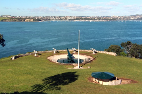
Features of the fort included twin six-inch disappearing guns, an underground magazine, barracks, observation posts, and engine room and searchlights. The structures situated on this site form a unique historic complex containing elements from all periods of coastal defence in New Zealand. The old fort, the last of the New Zealand designed twin 6 inch gun forts, was designed by Major Tudor-Boddam of the Royal Artillery and built between 1886 and 1889.
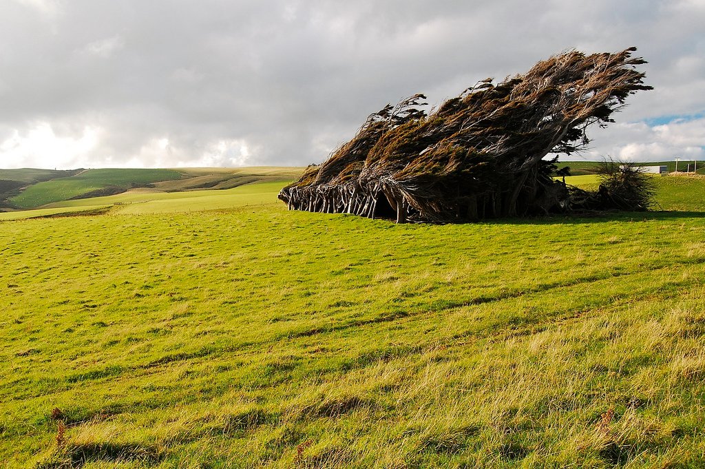
Spectacular views of windswept trees, southern ocean waves crashing onto the rocks and a photo opportunity at an iconic signpost are features of this southernmost point of the South Island.
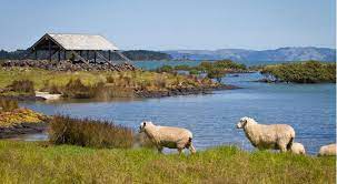
Slope Point lies approximately 24 km from the small settlement of Waikawa The signpost and cliff edge are an easy flat walk across private farmland from the carpark. If there are sheep present, there is no public access during the lambing season (September – November). Please respect the animals and do not disturb the livestock (sheep and/or cattle) if present.
Car park to signpost – 10 minutes one way
Situated close to Devonport town centre, Cheltenham Beach is a sandy beach within close proximity to the North Head Historic Reserve. The beach enjoys splendid views of Rangitoto Island and is a popular spot for walks and kayaking.
The beach is a good spot for picnics with a couple of benches located in shaded areas from the trees that overlook the beach. The calm water is ideal for swimming, with a couple of cold water showers available.
There is a small footpath that leads directly from the beach up to the summit of North Head Historic Reserve which offers sweeping views of the Hauraki Gulf, Waitemata Harbour and Auckland City.
The beach is a short walk from Torpedo Bay Historic Museum, a free to enter museum that provides a fascinating insight into New Zealand's military history. It's also a great place to grab a cup of coffee and enjoy the gorgeous views of the Auckland skyline and harbour. The scenic walk along King Edward Parade from the museum takes you back into the centre of Devonport.
Enjoy the history and charm of Auckland’s waterfront. Whether it be a family day out or a relaxing day with friends, there is so much to see and experience by foot or bike. Start your stroll or ride along Curran Street in Herne Bay. You'll find street parking here, or good nearby public transport.
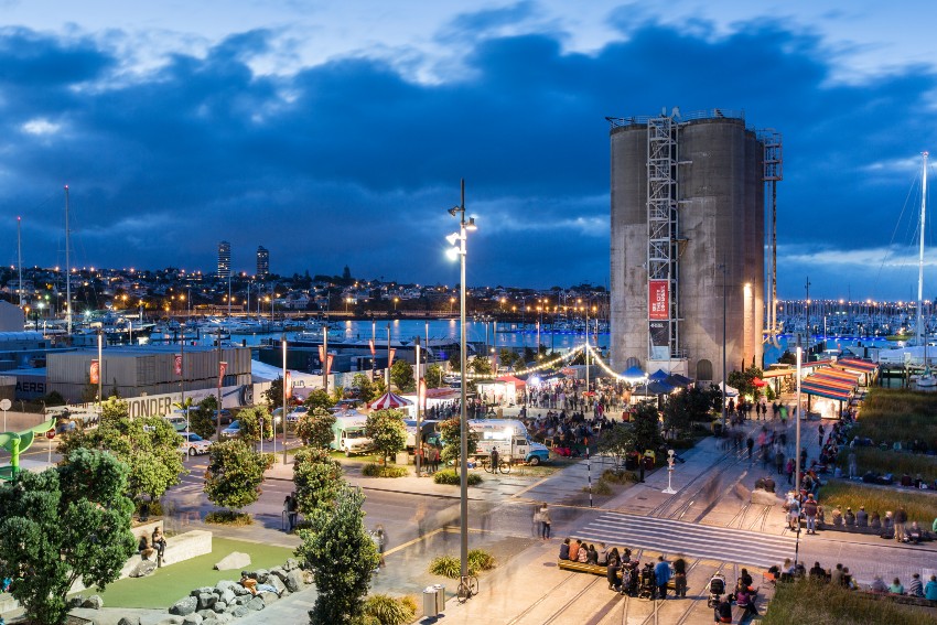
Nearby Point Erin Pool is a great spot for family fun during summer, with an outdoor pool, dive pool, hydro slides, spa, toddlers’ pool and family basketball court. Cross under the Auckland Harbour Bridge and admire stunning harbour views along the Westhaven Promenade. This is a great spot to view the sparkling Vector lights on the Harbour Bridge after dark. Head left up Beaumont Street to Silo Park. Silo Park is a hub of events: markets, outdoor movies, festivals and more.
Daldy Street Park will keep kids of all ages busy with a basketball court, playground, water play area and 7.5m slide. Further down Daldy Street, explore the community garden at the Dockline Tram Shed, Auckland Fish Market, or have a go on the public piano in the blue container.
Don't miss the Sounds of Sea (2009-2011, Company) and Wind Tree (1972, Michio Ihara) sculptures on North Wharf.
Dip your toes in the water at Karanga Plaza and admire the city view. At the kiosk there's even a bike fix-it stand on hand if you want to do a quick tune-up. Continue over Te Wero Bridge to the Viaduct precinct. There's plenty to see and do here, including sampling local restaurants and discovering New Zealand’s seafaring history at the Maritime Museum.
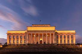
Auckland War Memorial Museum is one of New Zealand's first Museums. The Museum tells the story of New Zealand, its place in the Pacific and its people. The Museum is a war memorial for the province of Auckland and holds one of New Zealand's top three heritage libraries. It has pre-eminent Māori and Pacific collections, significant natural history resources and major social and military history collections, as well as decorative arts and pictorial collections.
For New Zealand Residents or citizens, the museum is free. They ask for a donation to help maintain the exhibits.
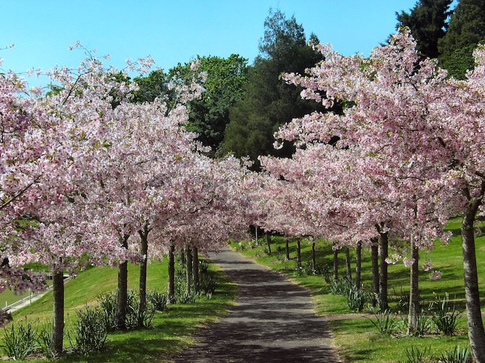
The Domain was set aside in 1880 as a 200-acre public reserve. In the 1880s, a pond and the area immediately surrounding it were used by the Auckland Acclimatisation Society as a testing ground for exotic fish and plant species. These early plantings developed into the initial site of Auckland's botanic gardens, leaving a legacy of magnificent mature trees for visitors to enjoy today. The pond, fed by an underground spring, went on to become Auckland's first water supply. Today it is populated by ducks and the outflow stream runs alongside the picturesque 'Lovers Walk' track through a hillside section of native forest. A second native forest walk leads through a gully, with the option to exit up into the middle of the historic Parnell shopping and restaurant area. The domain area was formed by volcanic activity 140,000 years ago. The large crater, which has a small scoria cone in its centre, forms a natural amphitheatre for large outdoor events like the annual 'Carols in the Park'. The level floor of the crater is covered with sports fields; a wooden cricket pavilion built in 1898 remains today. The rim of the crater offers panoramic views and is a great place to fly a kite. The beautiful Wintergardens, opened in 1913, consist of two large glasshouses each exhibiting either temperate or tropical plants. Between the glasshouses is an enclosed courtyard with fish pond, fountains and classical marble statues. The atmosphere here is charged with romance and often attracts newlyweds for photos on their big day. Behind the Wintergardens, an old quarry forms the perfect location for an extensive native fernery. At the top of the Domain hill stands the architecturally impressive Auckland Museum, a large neo-Greek building that was opened in 1929. A variety of sculptures have been installed throughout the domain and a brochure describing the walk to view them can be obtained from the museum.
Viaduct Harbour is a vibrant community situated in and around Auckland’s waterfront. With the continued development of residential apartments, it’s the place of choice for those wanting to live in the heart of the Supercity. Viaduct Harbour has a vibrant hospitality scene and is the hot spot for unforgettable dining experiences. And with world-class hotels and accommodation, it’s fast becoming on par with other harbour-based cities around the world as a destination of choice.
The neighbourhood of Wynyard Quarter wasn’t always a spot where you could have your feet planted firmly on dry land. Before being reclaimed, it was the tidal shoreline of the Waitemata Harbour, and looked very different to what you see today.
It was a mahinga kai (food-gathering place), and many pa (fortified villages) were built on the headlands with easy access down to the water. Waka were dragged ashore or launched for fishing expeditions, and people would wade in the low tide to collect shellfish and catch flounder.
Many points along the water’s edge had names that derived from how people interacted with the location. For example, Freemans Bay was once called Wai Kokota (Cockle Bay), and Kauri Point was once called Mangonui (Big Shark).
This heritage is reflected today in some of the names of public spaces throughout Wynyard Quarter, like Karanga (welcome) Plaza and Urunga (entry) Plaza, which are both important access points into the precinct.
With the continuation of kaitiakitanga (guardianship) in the approach to the Wynyard Quarter redevelopment, the theme is honoured by the care that’s being taken to preserve the heritage and character of the area while revitalising it and improving access.
As a key location for much of Tamaki Makaurau's marine activity, and being home to the Fish Market, this is an area that reflects the importance of the sea to Auckland’s growth since the 1800s.
The Western Reclamation, now known as Wynyard Quarter, was progressively constructed by Ports of Auckland's predecessor, the Auckland Harbour Board, to provide additional berthage capacity and flat land for port related activities, with the last component of the reclamation being completed in 1930. The area was initially utilised by the timber trade; in the 1930s, it started to be used for bulk petro-chemical storage, leading to the area becoming known as the 'Tank Farm'.
Changes to the way fuel was supplied to Tamaki Makaurau / Auckland meant that much of the land was no longer required for bulk fuel storage, freeing it up for progressive revitalisation. In 2005, Ports of Auckland developed a unique Western Reclamation vision and concept to transform the area into a harbourside community in stages over the next 25 years.
In 2007, Sea+City Projects was established to oversee the development of Wynyard Quarter. In 2010, as part of the super city merger, Waterfront Auckland (now Eke Panuku) was established as the Council Controlled Organisation to manage the development of Wynyard Quarter.
In August 2011, ahead of the Rugby World Cup being hosted in Aotearoa New Zealand, 500m of new public space was brought to life in the form of Silo Park, North Wharf, Karanga Plaza and the Wynyard Crossing Bridge.
Wynyard Quarter has continued to develop into the welcoming neighbourhood you see today. It has played host to many a major sporting event, such as the 36th America’s Cup, and it continues to evolve as a place where people can live, work, visit, relax and play.
Looking to the future, the next decade will continue to see the plan for Wynyard Quarter come to life. The point to the north of Wynyard Quarter will be developed into a park, and other areas in Wynyard Quarter will be developed to accommodate the growing needs of the community by introducing more housing, offices and public amenities.
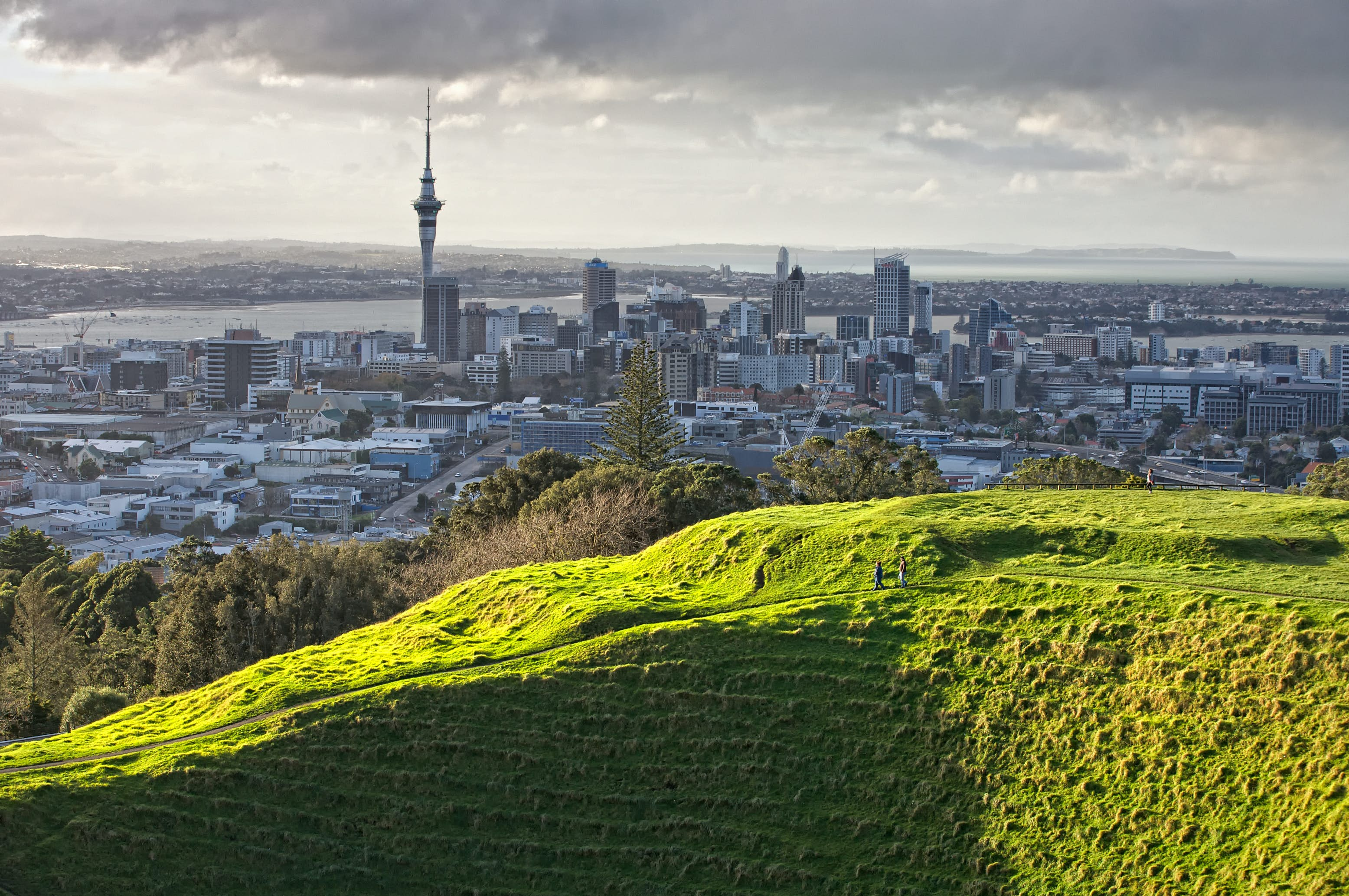
Mt Eden (Maungawhau) is one of the most prominent volcanic cones remaining in the Auckland region. Erupting about 15,000 years ago from three overlapping scoria cones, it formed a huge scoria mound with a central crater from the last eruption. Lava flowed out from the base of the mound, and in some places the lava is more than 60 metres thick.
Maungawhau was a significant fortified pā, large enough to provide refuge for several hundred people. Extensive earthworks modified the steep upper slopes of the cone.
Maungauika is a volcano forming a headland called North Head at the east end of the Waitemta Harbour in Auckland, New Zealand, in the suburb of Devonport. Known for its sweeping views over the harbour and the Hauraki Gulf, since 1885 the head was mainly used by the military as a coastal defence installation, which left a network of accessible old bunkers and tunnels as its legacy, forming part of the attraction. The site was protected as part of Hauraki Gulf Maritime Park in 1972, and listed as a Category I historic place in 2001. As part of a 2014 Treaty of Waitangi claim settlement the volcanic cone was officially named Maungauika and the reserve renamed Maungauika / North Head Historic Reserve. Maungauika is theMaori word for Mountain of Uika.
he original scoria cone has been substantially altered, first by marine erosion and later by the various generations of people who have occupied the headland. It was first used by Maori, and the Tainui waka was reputed to have put ashore close by at what is now Torpedo Bay. The Tainui people named the spring 'Takapuna', which was later used for the nearby beach. Some early photographs of the area show that they used to work gardens on the hill's lower slopes, though the pa fortifications of other cones in the area seem absent. European visitors during the 1850s have also described a settlement at the foot of the hill with gardens and racks for the drying of fish.
Takarunga is the original Māori name and means ‘hill standing above’, which is in reference to its height above adjacent Takararo / Mt Cambria which was a third maunga in Devonport. Sadly, Takararo was completely levelled by quarrying and is now the flat park known as Mt Cambria Reserve.
European settlers named the maunga Mt Victoria, after Queen Victoria. Another early European name for the maunga was Flagstaff Hill, after a signal station for the Port of Auckland was positioned on the summit in 1841. Takarunga / Mt Victoria has been a public reserve since 1880.
Used as a military position against a feared Russian invasion at the end of the 19th century, Takarunga / Mt Victoria has one of the last remaining disappearing guns in the world.
Takarunga is another former Māori pā (fortified village settlement). The northern slopes are largely original terracing dating to the pā, and pā storage pits are visible here on the upper slopes.
Although this maunga has been heavily modified in post-European times, it’s important to tread carefully and avoid walking on or through the historic terracing and pits. Please help preserve the history that still survives and stick to the formal tracks and sealed paths where they exist.
Start the path on King Edward Parade, by the water. Head up Church Street and turn left onto Kerr Street. Access the walk to the tihi (summit) from the signed access point off Kerr Street.
The tihi and summit road at Takarunga / Mt Victoria is permanently closed to private motor vehicles, making it a safer and more peaceful place for walking and cycling.
Dotted around the summit of the maunga you will come across a number of colourfully painted mushroom features. These are in fact the vents for a water pumping station which lies underneath the surface of the maunga.
Takarunga / Mt Victoria is a great place for stunning views across the Waitematā to the city centre and is also a great viewing place for watching ships arriving and departing.
Takarunga / Mt Victoria is one of 14 Tūpuna Maunga co-governed by the Tūpuna Maunga Authority.
Ambury Regional Park is situated 15 kilometres south of Auckland city on the shore of Manukau Harbour. The park is actually a working farm, making it a great park for families. Children will enjoy seeing sheep, cows, pigs, chickens, goats, and peacocks. Lanes between the animal enclosures allow visitors to get up close to the animals.
Birdwatchers will be kept busy with 86 species identified to date including knots, godwits, wrybills, little shags, and white-faced herons.
Sitting on ash-covered lava flows deposited by the eruption of Mangere Mountain18,000 years ago, the park provides visitors with views across to Manukau Heads and the Waitakere Ranges. The Maori originally had a large fortified pa on Mangere Mountain and used the area now known as Ambury Regional Park for gardening and an access point to seafood and launching canoes.
Ambury farm park lies among the southern suburbs fronting the Manukau Harbour. Take in the various farm animals as you wander around the open pasture. Ambury is a significant habitat for shorebirds and the coast has excellent examples of basalt lava flows.
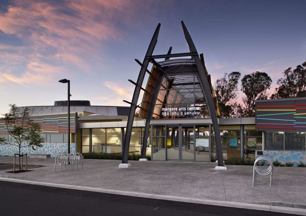
The centre is the home of Māori and Pacific visual and performing arts in Auckland.
It has two gallery spaces and a theatre with extensive lighting and audio set-up for performances, workshops, rehearsals and events and an enclosed community courtyard. The café supports local youth development programmes.
The centre's annual programme of events and exhibitions showcases the diversity and quality of arts, crafts and cultural activities that underpin the unique character of Māngere and Ōtāhuhu.
It also produces an annual April School Holiday theatre production.
Entry is free.
Charges may apply to workshops, theatre performances and special exhibitions.
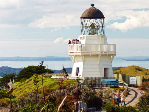
Top of the list is a trip to the historical Manukau Heads Lighthouse, jutting out from the tip of the peninsula, located in the Franklin district. The lighthouse is one of only a few in New Zealand that are open to the public and the views are amazing. The wind and salt spray will clear out the cobwebs too. On your way to the peninsula, stop by Waiuku, a historic town on the Sunset Coast. Explore the tranquil bays and rolling pastures of Āwhitu Regional Park on one of the short walks and mountain bike trails, or relax with a swim and a picnic at one of the safe, white-sand beaches. On the western side, the expansive and more rugged black-sand beach of Karioitahi is an awesome spot for activities on and off the water, including hang gliding, paragliding, blo-karting, surfing, 4 wheel driving and more.
This walkway follows the northern shore of the Manukau Harbour from the Onehunga Foreshore to Lynfield Cove in the west.