Whangarei
17.89°C

Whangarei
17.89°C
Waitakere City
16.98°C
Manukau City
17.11°C

Papakura
24.46°C
Hauraki
17.26°C

Waikato
17.67°C
Matamata
18.46°C
Hamilton
17.51°C
Otorohanga
18.52°C
Rotorua
16.6°C
Taupo
15.44°C
Tauranga
19.27°C
Kawerau
18.6°C
Whakatane
19.64°C
Gisborne
15.51°C
New Plymouth
16.98°C

Stratford
8.97°C
Ruapehu
14°C
Wanganui
17°C
Palmerston North
16.41°C
Wairoa
19.19°C
Hastings
18.84°C
Napier
18.49°C
Masterton
15.49°C
Carterton
15.66°C
Porirua
15.99°C
Lower Hutt
16.45°C

Wellington
15.79°C

Tasman
9.35°C
Nelson
16.27°C
Marlborough
3.22°C
Kaikoura
15.48°C
Christchurch
12.59°C
Ashburton
12.52°C
Timaru
13.37°C
Waitaki
11.32°C
Waimate
13.08°C

Queenstown
12.38°C
Dunedin
14.33°C
Southland
9.98°C
Gore
11.31°C
Invercargill
12.06°C
Blenheim
14.73°C
Te Anau
27.35°C
Wanaka
11.17°C
Kaikoura
13.38°C
Stratford
13.54°C
Upper Hutt
15.9°C
About
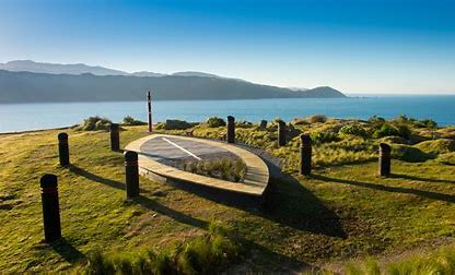
Turitea Pā formed part of a wider settlement known as “Te Kuripaka”, which included Te Motu o Poutoa to the east, and Marae-Tarata to the west. A tall viewing platform once stood on the same site when it was a Rangitāne o Manawatū pā. The lookout gave Rangitāne people an unobstructed view of who was coming up or down the river, with 360 degree views. Te Kuripaka dates to the 15th century, and the use of Turitea Pā as a lookout dates back as recently as the 1850s. Unfortunately, there are no remnants of the old platform that remain today.
Turitea means bright clear water. It is pronounced Tu – ri – te – a (Tu – rhymes with blue, Ri – rhymes with key, Te – said like tear, A – like you’re saying the ‘ar’ or the ‘a’ in car). Turitea Pā is about 2km up the pathway from the main He Ara Kotahi bridge. It is just a few hundred metres on from our Urban Eels platform, and has been commonly dubbed ‘the lookout’ since the pathway opened two years ago.


