Whangarei
17.89°C

Whangarei
17.89°C
Waitakere City
16.98°C
Manukau City
17.11°C

Papakura
24.46°C
Hauraki
17.26°C

Waikato
17.67°C
Matamata
18.46°C
Hamilton
17.51°C
Otorohanga
18.52°C
Rotorua
16.6°C
Taupo
15.44°C
Tauranga
19.27°C
Kawerau
18.6°C
Whakatane
19.64°C
Gisborne
15.51°C
New Plymouth
16.98°C

Stratford
8.97°C
Ruapehu
14°C
Wanganui
17°C
Palmerston North
16.41°C
Wairoa
19.19°C
Hastings
18.84°C
Napier
18.49°C
Masterton
15.49°C
Carterton
15.66°C
Porirua
15.99°C
Lower Hutt
16.45°C

Wellington
15.79°C

Tasman
9.35°C
Nelson
16.27°C
Marlborough
3.22°C
Kaikoura
15.48°C
Christchurch
12.59°C
Ashburton
12.52°C
Timaru
13.37°C
Waitaki
11.32°C
Waimate
13.08°C

Queenstown
12.38°C
Dunedin
14.33°C
Southland
9.98°C
Gore
11.31°C
Invercargill
12.06°C
Blenheim
14.73°C
Te Anau
27.35°C
Wanaka
11.17°C
Kaikoura
13.38°C
Stratford
13.54°C
Upper Hutt
15.9°C
About
Often described as New Zealand's greatest day walk, the Tongariro Alpine Crossing is a challenging journey across a remarkable volcanic landscape.
You can walk the track in either direction, but the more popular option begins at Mangatepopo Valley.
Beginning at Mangatepopo Valley near Whakapapa, the track follows a stream and the edges of old lava flows towards the valley head. Look out for varying patches of vegetation that reveal the age of the surrounding lava rock.
At the head of the valley, the trail becomes steeper, climbing from the valley to Mangatepopo Saddle between the mountains of Ngauruhoe and Tongariro. Stunning panoramic views look out over the volcanic terrain. On a clear day, you can see as far as Mount Taranaki.
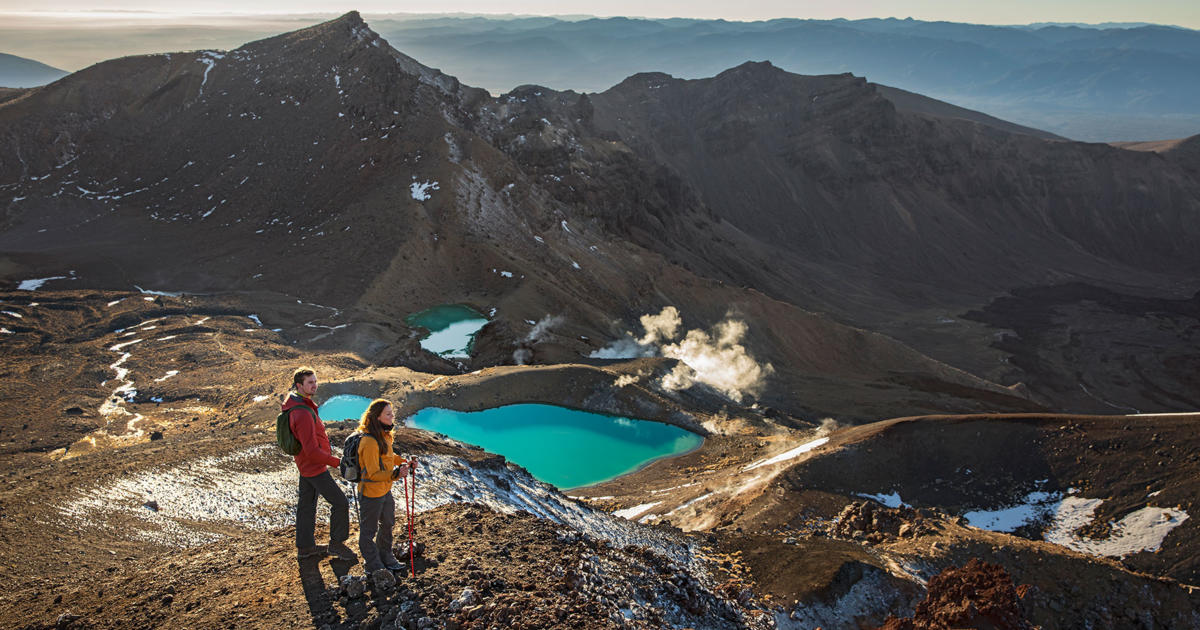
The trail leads from South Crater upwards towards Red Crater, the highest point of the Tongariro Alpine Crossing. The smell of sulphur is a reminder that this crater is still active.
From here you begin the descent, past the stunning Emerald Lakes. This is the highlight of the track and a great place to pause for photos.
The brilliant colour that gives them their name is caused by minerals leaching from the surrounding thermal environment.
The trail continues over Central Crater to the old volcanic vent of Blue Lake, before it rounds the flanks of North Crater and descends to Ketetahi Road end. The final section is a long descent through tussock slopes to cool green forest, a refreshing change to the volcanic landscape.


