Whangarei
17.89°C

Whangarei
17.89°C
Waitakere City
16.98°C
Manukau City
17.11°C

Papakura
24.46°C
Hauraki
17.26°C

Waikato
17.67°C
Matamata
18.46°C
Hamilton
17.51°C
Otorohanga
18.52°C
Rotorua
16.6°C
Taupo
15.44°C
Tauranga
19.27°C
Kawerau
18.6°C
Whakatane
19.64°C
Gisborne
15.51°C
New Plymouth
16.98°C

Stratford
8.97°C
Ruapehu
14°C
Wanganui
17°C
Palmerston North
16.41°C
Wairoa
19.19°C
Hastings
18.84°C
Napier
18.49°C
Masterton
15.49°C
Carterton
15.66°C
Porirua
15.99°C
Lower Hutt
16.45°C

Wellington
15.79°C

Tasman
9.35°C
Nelson
16.27°C
Marlborough
3.22°C
Kaikoura
15.48°C
Christchurch
12.59°C
Ashburton
12.52°C
Timaru
13.37°C
Waitaki
11.32°C
Waimate
13.08°C

Queenstown
12.38°C
Dunedin
14.33°C
Southland
9.98°C
Gore
11.31°C
Invercargill
12.06°C
Blenheim
14.73°C
Te Anau
27.35°C
Wanaka
11.17°C
Kaikoura
13.38°C
Stratford
13.54°C
Upper Hutt
15.9°C
About
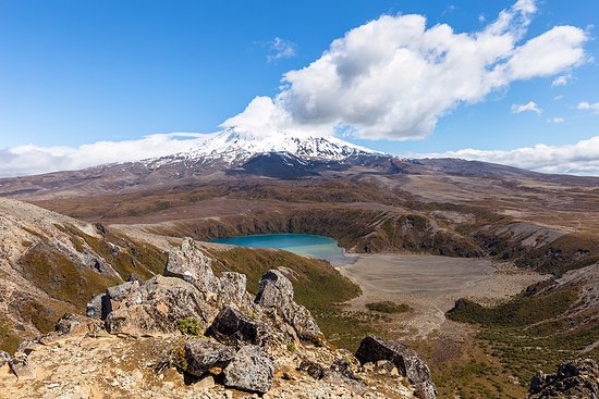
This track is an extension of the Taranaki Falls Walking Track.
After reaching Taranaki Falls, the track crosses undulating tussock country and alpine herb fields on a well formed and marked track. Further on, the track branches to the left to Tama Lakes, while the main track continues on to Waihohonu Hut. From this junction is a view of the lower lake (1,240 metres) with a surrounding backdrop of Mt Ngauruhoe to the North and behind you Mt Ruapehu.
The track climbs steeply to a viewpoint of the upper lake (1,440 metres). From here the track is not formed and is made of loose and uneven rock. There are no formed tracks down to the lakes, the descent to both is via steep unstable gullies. To ensure these pristine alpine lakes are kept free of weeds, do not touch or swim in the water.
This track requires much less uphill walking and exposure to alpine conditions than the Tongariro Alpine Crossing. It may be a great alternative during periods of bad weather.


