Whangarei
17.89°C

Whangarei
17.89°C
Waitakere City
16.98°C
Manukau City
17.11°C

Papakura
24.46°C
Hauraki
17.26°C

Waikato
17.67°C
Matamata
18.46°C
Hamilton
17.51°C
Otorohanga
18.52°C
Rotorua
16.6°C
Taupo
15.44°C
Tauranga
19.27°C
Kawerau
18.6°C
Whakatane
19.64°C
Gisborne
15.51°C
New Plymouth
16.98°C

Stratford
8.97°C
Ruapehu
14°C
Wanganui
17°C
Palmerston North
16.41°C
Wairoa
19.19°C
Hastings
18.84°C
Napier
18.49°C
Masterton
15.49°C
Carterton
15.66°C
Porirua
15.99°C
Lower Hutt
16.45°C

Wellington
15.79°C

Tasman
9.35°C
Nelson
16.27°C
Marlborough
3.22°C
Kaikoura
15.48°C
Christchurch
12.59°C
Ashburton
12.52°C
Timaru
13.37°C
Waitaki
11.32°C
Waimate
13.08°C

Queenstown
12.38°C
Dunedin
14.33°C
Southland
9.98°C
Gore
11.31°C
Invercargill
12.06°C
Blenheim
14.73°C
Te Anau
27.35°C
Wanaka
11.17°C
Kaikoura
13.38°C
Stratford
13.54°C
Upper Hutt
15.9°C
About
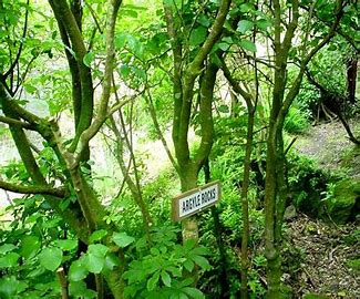
Sledge Track presents a stunning and varied adventure past swimming holes and waterfalls and up a series of steps to Hardings Park, where serious walkers can take a breather before tackling the more challenging loop tracks. Officially opened in 2003, Sledge Track follows an old roadway to Hardings Park, a scenic reserve of more than 860 hectares of native bush at the southern end of the Turitea Water Reserve. The track was restored by retired farmer Ian Argyle and volunteers using global positioning system readings and old survey maps to ensure the track sits within the road reserve. Families with small children can enjoy the first part of the track up to the swimming hole and picnic table (10-15 minutes), or if they are keen, push on to Argyle Rocks (30-50 minutes). Older children will enjoy the challenge of reaching the Lookout Point near the Quartz Creek junction. Beyond here Sledge Track climbs steeply for 1.5km to reach Toe Toe Junction. This climb and the tracks beyond are recommended for fit and experienced trampers only. See the map and walking times for more detailed guidance. Whether you are on the track for an easy walk to a cool swimming hole and picnic spot or a serious tramp, keep an eye out for kapokapowai, the giant bush dragonfly, or New Zealand’s native carnivorous land snail (Powelliphanta sp) and its favourite food the large native earthworm (up to 60cm long!) The track’s leaf litter is also home to a rare centipede. Overhead, listen out for the many Tui, Korimako (bellbirds), Kereru, Ruru and Karearea (NZ Falcon) that call the valley home. Palmerston North City Council traps and poisons intensively in the area to support the native wildlife and plants. Make your journey’s destination the Argyle Rocks in the Kahuterawa Stream, which following rain offers a
spectacular sight of cascading water. Go a little further along, between the Jill White Falls and Pritchards Point, to view the valley’s massive rimu tree. Twenty-five metres tall, the five-metre circumference tree is believed to be 600-800 years old.


