Whangarei
17.89°C

Whangarei
17.89°C
Waitakere City
16.98°C
Manukau City
17.11°C

Papakura
24.46°C
Hauraki
17.26°C

Waikato
17.67°C
Matamata
18.46°C
Hamilton
17.51°C
Otorohanga
18.52°C
Rotorua
16.6°C
Taupo
15.44°C
Tauranga
19.27°C
Kawerau
18.6°C
Whakatane
19.64°C
Gisborne
15.51°C
New Plymouth
16.98°C

Stratford
8.97°C
Ruapehu
14°C
Wanganui
17°C
Palmerston North
16.41°C
Wairoa
19.19°C
Hastings
18.84°C
Napier
18.49°C
Masterton
15.49°C
Carterton
15.66°C
Porirua
15.99°C
Lower Hutt
16.45°C

Wellington
15.79°C

Tasman
9.35°C
Nelson
16.27°C
Marlborough
3.22°C
Kaikoura
15.48°C
Christchurch
12.59°C
Ashburton
12.52°C
Timaru
13.37°C
Waitaki
11.32°C
Waimate
13.08°C

Queenstown
12.38°C
Dunedin
14.33°C
Southland
9.98°C
Gore
11.31°C
Invercargill
12.06°C
Blenheim
14.73°C
Te Anau
27.35°C
Wanaka
11.17°C
Kaikoura
13.38°C
Stratford
13.54°C
Upper Hutt
15.9°C
About
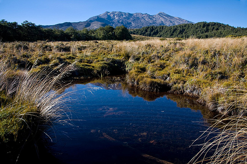
Highlights include lava formations, mountain beech trees, native ferns, waterfalls, golden silica rapids and wonderful views of Mt Ngauruhoe and Mt Ruapehu.
The Silica Rapids walk is an easy 7km loop track that will take you around 2.5 hours return.
The track begins 250 metres above Whakapapa Visitor Centre in Whakapapa Village.
Through mountain beech forest, the track travels alongside a cascading stream, arriving at the creamy-white terraces of Silica Rapids. Subalpine plants, amid a mixture of swamp and tussock country, feature around the track as it returns to the Bruce Road 2.5 kilometres above the starting point. This highly varied walk reveals a range of vegetation types and also has spectacular views of Ruapehu and Ngauruhoe on a clear day.


