Whangarei
17.89°C

Whangarei
17.89°C
Waitakere City
16.98°C
Manukau City
17.11°C

Papakura
24.46°C
Hauraki
17.26°C

Waikato
17.67°C
Matamata
18.46°C
Hamilton
17.51°C
Otorohanga
18.52°C
Rotorua
16.6°C
Taupo
15.44°C
Tauranga
19.27°C
Kawerau
18.6°C
Whakatane
19.64°C
Gisborne
15.51°C
New Plymouth
16.98°C

Stratford
8.97°C
Ruapehu
14°C
Wanganui
17°C
Palmerston North
16.41°C
Wairoa
19.19°C
Hastings
18.84°C
Napier
18.49°C
Masterton
15.49°C
Carterton
15.66°C
Porirua
15.99°C
Lower Hutt
16.45°C

Wellington
15.79°C

Tasman
9.35°C
Nelson
16.27°C
Marlborough
3.22°C
Kaikoura
15.48°C
Christchurch
12.59°C
Ashburton
12.52°C
Timaru
13.37°C
Waitaki
11.32°C
Waimate
13.08°C

Queenstown
12.38°C
Dunedin
14.33°C
Southland
9.98°C
Gore
11.31°C
Invercargill
12.06°C
Blenheim
14.73°C
Te Anau
27.35°C
Wanaka
11.17°C
Kaikoura
13.38°C
Stratford
13.54°C
Upper Hutt
15.9°C
About
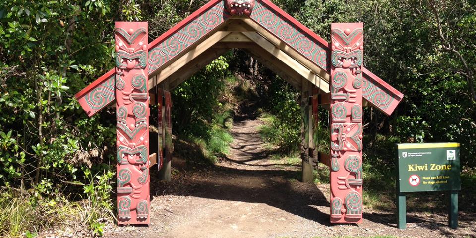
Ohope Scenic Reserve contains steep hill country extending south of the Ōhope escarpment. The reserve forms part of a significant coastal landscape and has outstanding scenic and conservation values. The reserve includes one of the country's largest remaining coastal pohutukawa forests.
Ngāti Awa hapu occupied and established early relationships with the Ōhope area. In the late 18th century, Ngāti Hokopu and Ngāti Wharepāia hapu of Ngāti Awa were prominent within the reserve and surrounding areas, and they remain so today.
A number of pā sites near Ohope Scenic Reserve demonstrate the strong historical associations of Ngāti Awa with the area. Eastwards, near the coast below the reserve, are the two strategic pā called Maungateone and Te Paripari. Further along Ōhope escarpment were Mihi Marino and Raukawarua Pā. There were pā within the reserve area but their names have been lost over time.
Particular stretches of Ohope Scenic Reserve have their own traditions. East of Otumanu along the cliff face is the path known as Te Ara-aka, which means ‘pathway of the vine’.
Ohope Scenic Reserve was rich in natural resources and provided an abundance of wildlife, food and medicinal resources for Ngāti Awa hapū. The area’s use is evidenced by the discovery of artefacts along the creek bed of Te Hiku o te Tuna.
Ngāti Awa have always maintained considerable knowledge of the lands of the reserve - their history, traditional trails, places for gathering food and other taonga, and ways in which to use resources. The ethics of sustainable resource management and conservation have always been, and continue to be, at the heart of the relationship of Ngāti Awa with Ohope Scenic Reserve.
Ngāti Awa representation on the Whakatāne Kiwi Trust and active involvement in animal predator control work on the adjoining Ngāti Awa Farm are two of the many activities that demonstrate the enduring relationship of Ngāti Awa with the Ohope Scenic Reserve. Revival and expansion of this relationship is important to Ngāti Awa.
Ohope Scenic Reserve is ecologically important, supporting nationally significant pohutukawa forest and North Island brown kiwi.
The reserve is surrounded by land that is used for a variety of purposes including residential, landfill, road reserve and farming. Ongoing management of pest plants and animals in the reserve and on neighbouring private properties is needed to ensure that the health of the reserve is protected and enhanced.
There are four main streams and several tributaries within Ohope Scenic Reserve, all of which have significant ecological values. The Maraetotara Stream, for example, has been identified as a habitat for giant kokopu, short-jawed kokopu, short-finned eel, long-finned eel, red-finned bully, torrent-fish, common bully and common smelt. Te Hiku o te Tuna Stream, running adjacent to Ohope Hill Road and discharging to the coast at Ōhope, contains banded kokopu.
The reserve, a popular walking and running area, is highly valued by the community for its recreational opportunities, and for the outstanding natural and cultural landscape which it provides so close to Whakatāne, Ōhope and the coast.


