Whangarei
17.89°C

Whangarei
17.89°C
Waitakere City
16.98°C
Manukau City
17.11°C

Papakura
24.46°C
Hauraki
17.26°C

Waikato
17.67°C
Matamata
18.46°C
Hamilton
17.51°C
Otorohanga
18.52°C
Rotorua
16.6°C
Taupo
15.44°C
Tauranga
19.27°C
Kawerau
18.6°C
Whakatane
19.64°C
Gisborne
15.51°C
New Plymouth
16.98°C

Stratford
8.97°C
Ruapehu
14°C
Wanganui
17°C
Palmerston North
16.41°C
Wairoa
19.19°C
Hastings
18.84°C
Napier
18.49°C
Masterton
15.49°C
Carterton
15.66°C
Porirua
15.99°C
Lower Hutt
16.45°C

Wellington
15.79°C

Tasman
9.35°C
Nelson
16.27°C
Marlborough
3.22°C
Kaikoura
15.48°C
Christchurch
12.59°C
Ashburton
12.52°C
Timaru
13.37°C
Waitaki
11.32°C
Waimate
13.08°C

Queenstown
12.38°C
Dunedin
14.33°C
Southland
9.98°C
Gore
11.31°C
Invercargill
12.06°C
Blenheim
14.73°C
Te Anau
27.35°C
Wanaka
11.17°C
Kaikoura
13.38°C
Stratford
13.54°C
Upper Hutt
15.9°C
About
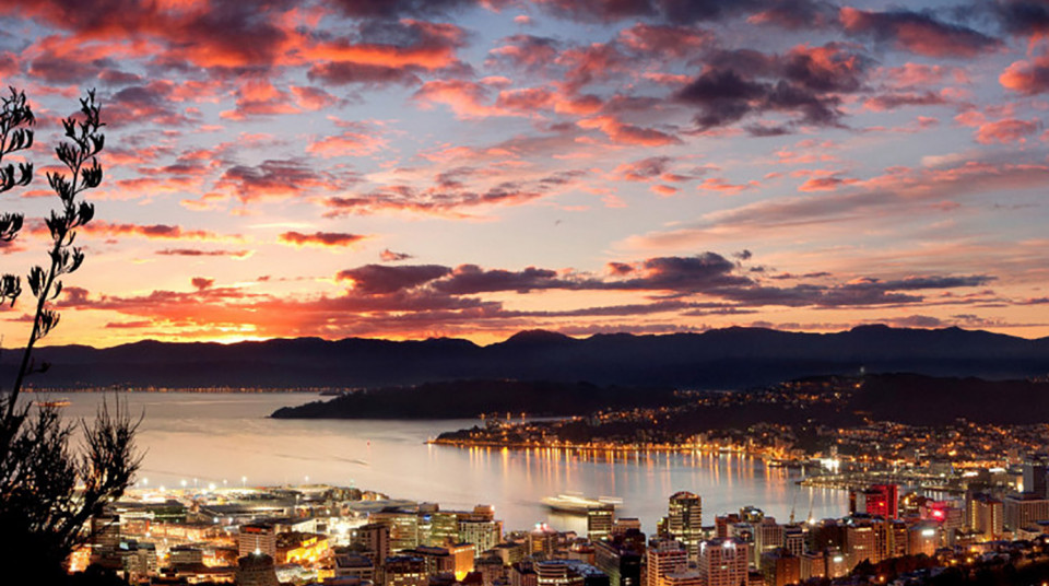
Mount Victoria provides stunning 360 degree views of Wellington City, the harbour and the ocean to the south. Car and bus access is via Alexandra Road, while walking tracks lead from Oriental Parade and Majoribanks Street.
Legend has it that Wellington harbour, originally a land-locked lake, was home to two large and very active taniwha (sea monsters). One taniwha forged a passage to the open sea creating the entrance to the harbour. The second, named Whataitai, tried a different route, became stranded and died. It is believed that Tangi-te keo (Mt Victoria) was named after the soul of Whataitai.
Mount Victoria is part of the Wellington Town Belt, land set aside in 1841 by the colonial New Zealand Company for a "public recreation ground for the inhabitants of Wellington". It's a great place for walking, jogging and mountain biking.


