Whangarei
17.89°C

Whangarei
17.89°C
Waitakere City
16.98°C
Manukau City
17.11°C

Papakura
24.46°C
Hauraki
17.26°C

Waikato
17.67°C
Matamata
18.46°C
Hamilton
17.51°C
Otorohanga
18.52°C
Rotorua
16.6°C
Taupo
15.44°C
Tauranga
19.27°C
Kawerau
18.6°C
Whakatane
19.64°C
Gisborne
15.51°C
New Plymouth
16.98°C

Stratford
8.97°C
Ruapehu
14°C
Wanganui
17°C
Palmerston North
16.41°C
Wairoa
19.19°C
Hastings
18.84°C
Napier
18.49°C
Masterton
15.49°C
Carterton
15.66°C
Porirua
15.99°C
Lower Hutt
16.45°C

Wellington
15.79°C

Tasman
9.35°C
Nelson
16.27°C
Marlborough
3.22°C
Kaikoura
15.48°C
Christchurch
12.59°C
Ashburton
12.52°C
Timaru
13.37°C
Waitaki
11.32°C
Waimate
13.08°C

Queenstown
12.38°C
Dunedin
14.33°C
Southland
9.98°C
Gore
11.31°C
Invercargill
12.06°C
Blenheim
14.73°C
Te Anau
27.35°C
Wanaka
11.17°C
Kaikoura
13.38°C
Stratford
13.54°C
Upper Hutt
15.9°C
About
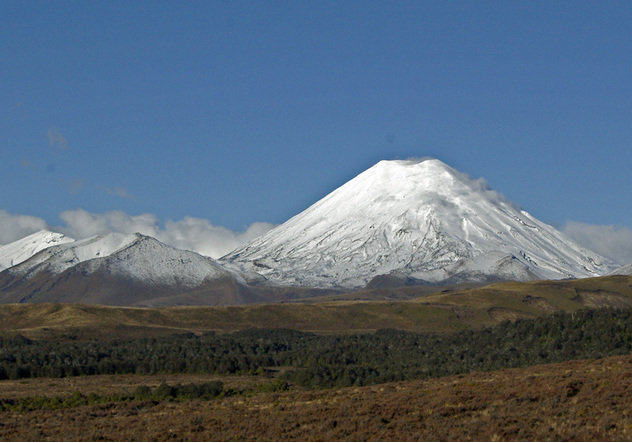
Ngauruhoe (7,500 ft) has an almost perfect cone rising 3,000 ft above the southern slopes of Tongariro. It has been the most continuously active of New Zealand volcanoes in the recent past. Eruptions from this mountain were regarded by the Maori as a sign of war. Except on the east, young lava flows have reached their base on all sides and these have a loose, rugged, clinkery surface. Since 1839 considerable changes have occurred within the crater. The more notable eruptions were in 1841 with ash eruption which truncated the top, in 1855 when the west side of the crater wall collapsed, in 1859 when the east wall of the crater collapsed, in 1870 with ash eruption and lava flow, in 1949 with ash eruption and lava flow, and in 1954–55 again with ash eruption and lava flow.


