Whangarei
17.89°C

Whangarei
17.89°C
Waitakere City
16.98°C
Manukau City
17.11°C

Papakura
24.46°C
Hauraki
17.26°C

Waikato
17.67°C
Matamata
18.46°C
Hamilton
17.51°C
Otorohanga
18.52°C
Rotorua
16.6°C
Taupo
15.44°C
Tauranga
19.27°C
Kawerau
18.6°C
Whakatane
19.64°C
Gisborne
15.51°C
New Plymouth
16.98°C

Stratford
8.97°C
Ruapehu
14°C
Wanganui
17°C
Palmerston North
16.41°C
Wairoa
19.19°C
Hastings
18.84°C
Napier
18.49°C
Masterton
15.49°C
Carterton
15.66°C
Porirua
15.99°C
Lower Hutt
16.45°C

Wellington
15.79°C

Tasman
9.35°C
Nelson
16.27°C
Marlborough
3.22°C
Kaikoura
15.48°C
Christchurch
12.59°C
Ashburton
12.52°C
Timaru
13.37°C
Waitaki
11.32°C
Waimate
13.08°C

Queenstown
12.38°C
Dunedin
14.33°C
Southland
9.98°C
Gore
11.31°C
Invercargill
12.06°C
Blenheim
14.73°C
Te Anau
27.35°C
Wanaka
11.17°C
Kaikoura
13.38°C
Stratford
13.54°C
Upper Hutt
15.9°C
About
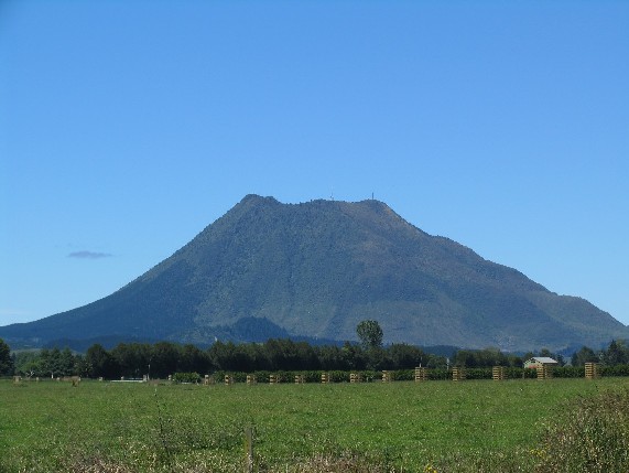
Putauaki, also known as Mount Edgecumbe, is a dacite volcanic cone in the Bay of Plenty Region of New Zealand. Located 50 km east of Rotorua and three kilometres east of Kawerau, it is the easternmost vent of the Okataina volcanic centre, within the Taupo Volcanic Zone. The mountain rises to 820m above sea level, and is visible from the waters of the Bay of Plenty, 30 km to the north. Climbing to the summit of Putauaki takes about 2 hours up and around 1.5 hours to come down. A permit is required to access the road and to climb the mountain. These permits can be obtained from MIL (Maori Investments), who are located on Waterhouse Street Extension (off River Road) in Kawerau. They can be contacted on 07 323 8146, and are only open Monday - Friday. If you require a permit for the weekend, these must be pre-arranged prior to that date.


