Whangarei
17.89°C

Whangarei
17.89°C
Waitakere City
16.98°C
Manukau City
17.11°C

Papakura
24.46°C
Hauraki
17.26°C

Waikato
17.67°C
Matamata
18.46°C
Hamilton
17.51°C
Otorohanga
18.52°C
Rotorua
16.6°C
Taupo
15.44°C
Tauranga
19.27°C
Kawerau
18.6°C
Whakatane
19.64°C
Gisborne
15.51°C
New Plymouth
16.98°C

Stratford
8.97°C
Ruapehu
14°C
Wanganui
17°C
Palmerston North
16.41°C
Wairoa
19.19°C
Hastings
18.84°C
Napier
18.49°C
Masterton
15.49°C
Carterton
15.66°C
Porirua
15.99°C
Lower Hutt
16.45°C

Wellington
15.79°C

Tasman
9.35°C
Nelson
16.27°C
Marlborough
3.22°C
Kaikoura
15.48°C
Christchurch
12.59°C
Ashburton
12.52°C
Timaru
13.37°C
Waitaki
11.32°C
Waimate
13.08°C

Queenstown
12.38°C
Dunedin
14.33°C
Southland
9.98°C
Gore
11.31°C
Invercargill
12.06°C
Blenheim
14.73°C
Te Anau
27.35°C
Wanaka
11.17°C
Kaikoura
13.38°C
Stratford
13.54°C
Upper Hutt
15.9°C
About
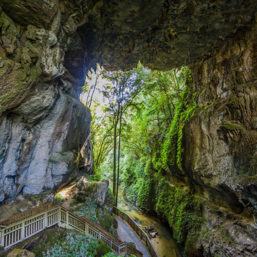
Walk through an impressive limestone gorge that passes underneath a 17 m high natural arch.
Mangapohue Natural Bridge is a highlight on the scenic drive from Waitomo Village to Marokopa. The track is pushchair-friendly and follows a boardwalk through an impressive limestone gorge that takes you underneath a natural bridge.
The 17 m high limestone arch, which spans the Mangapohue Stream, is all that remains of an ancient cave system. From here the track becomes stepped and passes under the bridge giving a superb view of the ceiling studded with stalactite-like formations and an excellent view back down the gorge.
The track continues for over farmland. Follow the marker posts around to the right and up the hill where you can see 25 million year old fossilised oysters exposed in the limestone outcrops. Follow the marker posts until you cross a stile back into the reserve heading back to the car park.


