Whangarei
17.89°C

Whangarei
17.89°C
Waitakere City
16.98°C
Manukau City
17.11°C

Papakura
24.46°C
Hauraki
17.26°C

Waikato
17.67°C
Matamata
18.46°C
Hamilton
17.51°C
Otorohanga
18.52°C
Rotorua
16.6°C
Taupo
15.44°C
Tauranga
19.27°C
Kawerau
18.6°C
Whakatane
19.64°C
Gisborne
15.51°C
New Plymouth
16.98°C

Stratford
8.97°C
Ruapehu
14°C
Wanganui
17°C
Palmerston North
16.41°C
Wairoa
19.19°C
Hastings
18.84°C
Napier
18.49°C
Masterton
15.49°C
Carterton
15.66°C
Porirua
15.99°C
Lower Hutt
16.45°C

Wellington
15.79°C

Tasman
9.35°C
Nelson
16.27°C
Marlborough
3.22°C
Kaikoura
15.48°C
Christchurch
12.59°C
Ashburton
12.52°C
Timaru
13.37°C
Waitaki
11.32°C
Waimate
13.08°C

Queenstown
12.38°C
Dunedin
14.33°C
Southland
9.98°C
Gore
11.31°C
Invercargill
12.06°C
Blenheim
14.73°C
Te Anau
27.35°C
Wanaka
11.17°C
Kaikoura
13.38°C
Stratford
13.54°C
Upper Hutt
15.9°C
About
The walkway juts from the rugged east coast of the South Island, with a backdrop of steep mountains, snow-capped in winter. The area's wildlife includes whales, dolphins, seals, birds and crayfish. An impressive collection of information panels along the walkway explains the rich history, geology, animals and plants that make the area so special.
The track crosses the peninsula’s clifftop, with excellent views of the Seaward Kaikōura Range, ocean and coastline, to South Bay. It returns to the township via South Bay and Toms Track.
The track can be exposed in places. Stay on the formed track and supervise children and at all times.
To fully explore and enjoy the features of the walk, allow at least three hours to complete the whole walkway.
Time: 50 min
Distance: 4.4 km
From the town centre, follow the footpath and road verge along The Esplanade, Avoca Street and Fyffe Quay to Point Kean. On the way, look out for the interpretation signs on The Esplanade opposite Brighton and Margate Streets, telling stories of 'Life on the edge', a community living by the sea — the land, the sea and the people.
Near Fyffe House, a sign details the early European settlement in Kaikōura. At nearby Armers Beach, the story tells of the importance this site holds for the local community, both past and present, for the shelter it provides.
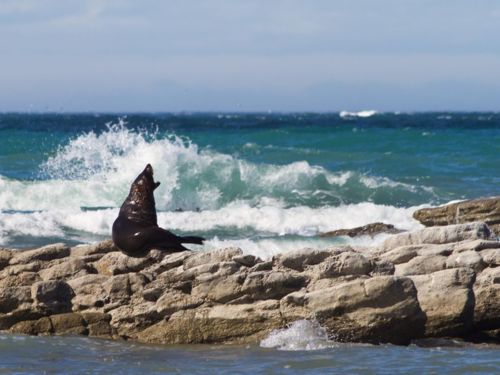
At Point Kean carpark seals are likely to be present in the surrounding area. Most of the seals in the carpark are males. They may appear to be harmless – however, they are capable of becoming aggressive if disturbed and can inflict a nasty, infectious bite.
The seals on the rocky platforms out from the carpark are females and their pups. For your safety and to avoid disturbing the seals, remain atleast 20 m from any seal.
There are toilets at the carpark.
Time: 5 min
Distance: 200 m
Walk up the hill from the car park to a lookout platform. This platform, designed in the shape of a waka, gives views of both the sea and the mountains. Interpretation panels provide stories of the land, the sea and the people who lived here.
From the carpark when the tide is low, you're able to explore the open tidal platforms. You may see wading birds, such as oystercatchers and reef herons, feeding on the platforms. Shags are common and blue penguins may be seen bobbing just offshore.
Just off the tidal platforms is an excellent diving and snorkelling area for those who want a closer look at the marine life.
Time: 25 min
Distance: 1.5 km
Beyond the lookout platform, follow the track along the clifftop for superb views of rugged cliff formations, tidal platforms and the Seaward Kaikōura Range.
An interpretation panel on this section of the walkway explains that, hundreds of years ago, the peninsula was forested with many species of native New Zealand trees and plants. Most of this vegetation was removed during successive waves of human development, leaving small, remnant outcrops of hardy shrubs and plants clinging to the steep cliff faces.
This track down a stairway follows a former whalers’ route down the cliff to the shoreline. A prominent feature in this area is known as 'the Sugarloaf'. Don't climb this landmark, to prevent further erosion.
View seabirds, seals, walkers, divers, crayfish floats and fishing boats. Out to sea, you may see scores of seabirds feeding frantically on small fish herded to the surface by bigger fish or dolphins.
Take care to avoid disturbing any wildlife along the shoreline as there are large colonies of birds in the area. These are particularly vulnerable to disturbance during the breeding season over summer.
Return back up via the same cliff track, as tides or seals along the shoreline may prevent you from returning to the carpark.
Interpretation on the clifftop overlooking 'the Sugarloaf' describes the point below as 'Bird City' – the largest red-billed gull colony in the South Island. From here, whalers kept a vigil over the sea, looking out for their quarry. Around the corner in Whalers Bay was the launching point for the whalers’ boats.
Time: 20 min
Distance: 1.1 km
On the sea cliffs near this section of the walkway, is a new colony of Hutton’s shearwater behind a large predator-proof fence. In summer you may see large rafts of these birds sitting on the water.
At nightfall, after feeding at sea all day, they return to their breeding colonies high up in the Seaward Kaikōura Ranges. An interpretation panel explains the work being undertaken to establish a colony on the Kaikōura Peninsula.
Time: 15 min
Distance: 600 m
From the South Bay viewpoint, the walkway descends to a fully accessible path that leads to an information shelter and toilets at South Bay. Before descending to South Bay, you can view the tidal platforms and the view south. The interpretation panel here has a landscape profile identifying the mountain peaks and Goose Bay.
Time: 1 hr 5 min
Distance: 3.9 km
From the South Bay shelter, return to Kaikōura town centre by following the marker posts along the coast towards the marina. Follow the marker posts to South Bay Parade and cross to South Bay Track, walk up the hill, cross Scarborough Street and walk down Toms Track to return to The Esplanade.
Time: 5 min
Distance: 250 m
At South Bay, a fully accessible path from the carpark takes you to Limestone Bay. The elevated walkway above the tidal platform gives wonderful coastal views and allows you to smell the ocean and watch the birds.
Time: 10 min
Distance: 350 m
This climb up to a viewpoint on the clifftop rewards you with superb views of tidal platforms, cliff formations and Haumuri Bluffs to the south.
The walkway starts from Kaikōura township. Kaikōura lies almost midway between Picton (154 km) and Christchurch (183 km) off SH1 on the east coast of the South Island. Regular bus and train services pass through the town.
There is no scheduled public transport from Kaikōura to the walkway but you may be able to arrange commercial transport.


