Whangarei
17.89°C

Whangarei
17.89°C
Waitakere City
16.98°C
Manukau City
17.11°C

Papakura
24.46°C
Hauraki
17.26°C

Waikato
17.67°C
Matamata
18.46°C
Hamilton
17.51°C
Otorohanga
18.52°C
Rotorua
16.6°C
Taupo
15.44°C
Tauranga
19.27°C
Kawerau
18.6°C
Whakatane
19.64°C
Gisborne
15.51°C
New Plymouth
16.98°C

Stratford
8.97°C
Ruapehu
14°C
Wanganui
17°C
Palmerston North
16.41°C
Wairoa
19.19°C
Hastings
18.84°C
Napier
18.49°C
Masterton
15.49°C
Carterton
15.66°C
Porirua
15.99°C
Lower Hutt
16.45°C

Wellington
15.79°C

Tasman
9.35°C
Nelson
16.27°C
Marlborough
3.22°C
Kaikoura
15.48°C
Christchurch
12.59°C
Ashburton
12.52°C
Timaru
13.37°C
Waitaki
11.32°C
Waimate
13.08°C

Queenstown
12.38°C
Dunedin
14.33°C
Southland
9.98°C
Gore
11.31°C
Invercargill
12.06°C
Blenheim
14.73°C
Te Anau
27.35°C
Wanaka
11.17°C
Kaikoura
13.38°C
Stratford
13.54°C
Upper Hutt
15.9°C
About
The walking track follows an easy grade. Return the same way, or create a circuit using the Coromandel mountain bike track but note this is much steeper and slippery in places.
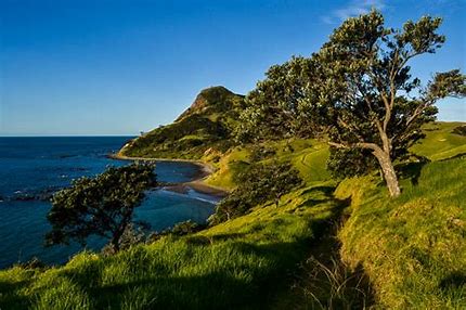
The coastal walk between Stony and Fletcher Bays crosses farmland and goes through coastal forest with views of the Pinnacles, Great Barrier Island (Aotea Island) to the north and Cuvier Island (Repanga Island) in the east. The track follows an easy gradient with a short steep section in to and out of Poley Bay. It is part of an old bridle path formed by early pioneers to link the two bays. Swimming here is hazardous because of submerged rocks.
This walk will take approximately 7 hours in total, and is 20kms return journey.
The more challenging mountain bike track follows a stock route across farmland and regenerating forest, and rewards walkers with spectacular views of the ranges and islands of the Hauraki Gulf from the top of the track. For mountain bikers, this is a steep traverse, often slippery and challenging and only suitable for advanced riders and people with a good level of fitness.
From Stony Bay campsite, orange triangles mark the track, which turns left at the ford and past the two houses. The track continues over farmland for a short distance and then heads up a steep clay track.
Allow 1 hr 30 min to reach the top. Following the fenceline down, there are views of Port Jackson and Fletcher Bay. The two tracks meet below a historic shepherd's hut just north of Poley Bay and from there it is another 40 min to Fletcher Bay. Returning back to Stony Bay from this point will take about 2 hr 30 min. Cell phone coverage is limited.


