Whangarei
17.89°C

Whangarei
17.89°C
Waitakere City
16.98°C
Manukau City
17.11°C

Papakura
24.46°C
Hauraki
17.26°C

Waikato
17.67°C
Matamata
18.46°C
Hamilton
17.51°C
Otorohanga
18.52°C
Rotorua
16.6°C
Taupo
15.44°C
Tauranga
19.27°C
Kawerau
18.6°C
Whakatane
19.64°C
Gisborne
15.51°C
New Plymouth
16.98°C

Stratford
8.97°C
Ruapehu
14°C
Wanganui
17°C
Palmerston North
16.41°C
Wairoa
19.19°C
Hastings
18.84°C
Napier
18.49°C
Masterton
15.49°C
Carterton
15.66°C
Porirua
15.99°C
Lower Hutt
16.45°C

Wellington
15.79°C

Tasman
9.35°C
Nelson
16.27°C
Marlborough
3.22°C
Kaikoura
15.48°C
Christchurch
12.59°C
Ashburton
12.52°C
Timaru
13.37°C
Waitaki
11.32°C
Waimate
13.08°C

Queenstown
12.38°C
Dunedin
14.33°C
Southland
9.98°C
Gore
11.31°C
Invercargill
12.06°C
Blenheim
14.73°C
Te Anau
27.35°C
Wanaka
11.17°C
Kaikoura
13.38°C
Stratford
13.54°C
Upper Hutt
15.9°C
About
Balclutha is the largest settlement in the Clutha District. In 1853 James and son John McNeil established a ferry across the Clutha River. The first crown grants following surveying went to the McNeil’s, and from 1858 to John Barr. The Otago Provincial government proclaimed a public ferry in 1857 and built an accommodation house on the south bank of the river. The ferry was leased to John Barr. Due to the increase of traffic caused by the goldrush, the Provincial government purchased a punt in 1861. This punt was too small, and several death causing accidents occurred as a result. In 1863 the Provincial government purchased a larger safer punt. Stores, hotels, and other services began to pop up at the crossing and in 1863 sections at Balclutha were auctioned off signifying the beginning of the township. Following this, many businesses began operating including bakers, blacksmiths, photographers, bootmakers etc. At this time, John Barr established the General Import Company which lasted well into the 20th century with the Import Store a key feature on the main street for many years.
During these early days, the water network was extremely important for transportation of people and goods. As a result, a steamer operated from the Balclutha river mouth up to Tuapeka Mouth. This service continued until the construction of the Clydevale bridge in 1939.
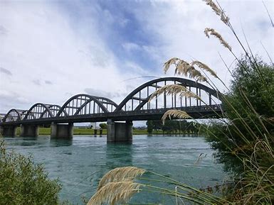
The first Balclutha bridge opened in 1868. This bridge was subsequently taken out by the broken Beaumont bridge which had been washed out during flooding in 1878. A replacement bridge was built until 1881. With the improves in transportation technology and motor car ownership increasing, the 1881 wooden bridge was no longer fit for purpose and was upgraded to the present bridge in 1935.
The railway reached the north bank of the Clutha in 1875. It took until 1878 for the rail bridge to be completed, however shortly after this the link to Invercargill opened in January 1879.With the improvements in roading throughout the Clutha District, Balclutha is now the main service town in South Otago providing for an extensive community who largely work in the agricultural.


