Whangarei
17.89°C

Whangarei
17.89°C
Waitakere City
16.98°C
Manukau City
17.11°C

Papakura
24.46°C
Hauraki
17.26°C

Waikato
17.67°C
Matamata
18.46°C
Hamilton
17.51°C
Otorohanga
18.52°C
Rotorua
16.6°C
Taupo
15.44°C
Tauranga
19.27°C
Kawerau
18.6°C
Whakatane
19.64°C
Gisborne
15.51°C
New Plymouth
16.98°C

Stratford
8.97°C
Ruapehu
14°C
Wanganui
17°C
Palmerston North
16.41°C
Wairoa
19.19°C
Hastings
18.84°C
Napier
18.49°C
Masterton
15.49°C
Carterton
15.66°C
Porirua
15.99°C
Lower Hutt
16.45°C

Wellington
15.79°C

Tasman
9.35°C
Nelson
16.27°C
Marlborough
3.22°C
Kaikoura
15.48°C
Christchurch
12.59°C
Ashburton
12.52°C
Timaru
13.37°C
Waitaki
11.32°C
Waimate
13.08°C

Queenstown
12.38°C
Dunedin
14.33°C
Southland
9.98°C
Gore
11.31°C
Invercargill
12.06°C
Blenheim
14.73°C
Te Anau
27.35°C
Wanaka
11.17°C
Kaikoura
13.38°C
Stratford
13.54°C
Upper Hutt
15.9°C
About
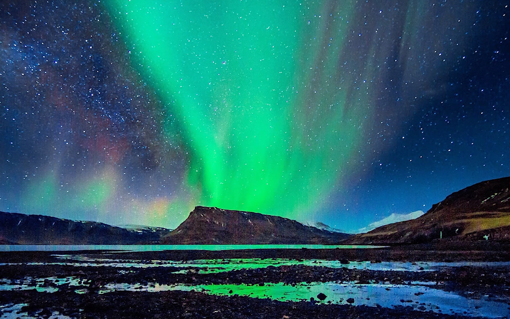
Aurora australis (also known as the southern lights, and southern polar lights) is the southern hemisphere counterpart to the aurora borealis. In the sky, an aurora australis takes the shape of a curtain of light, or a sheet, or a diffuse glow; it most often is green, sometimes red, and occasionally other colors too.
Like its northern sibling, the aurora australis is strongest in an oval centered on the south magnetic pole. This is because they are the result of collisions between energetic electrons (sometimes also protons) and atoms and molecules in the upper atmosphere … and the electrons get their high energies by being accelerated by solar wind magnetic fields and the Earth’s magnetic field (the motions are complicated, but essentially the electrons spiral around the Earth’s magnetic field lines and ‘touch down’ near to where those lines become vertical).
So by far the best place to see aurorae in the southern hemisphere is Antarctica! Oh, and at night too. When the solar cycle is near its maximum, aurora australis are sometimes visible in Dunedin, by Hoopers Inlet.
Hoopers Inlet is one of two large inlets in the Pacific coast of Otago Peninsula, in the South Island of New Zealand.
The origin of the name is a little confused; there was an early settler family called Hooper who lived nearby, but the name appears on charts made prior to their arrival in the area. A. W. Reed has suggested that the name is a corruption of "Cooper's Inlet", named for Daniel Cooper, the ship's captain of the Unity, which operated in the area during the Peninsula's years as a base for sealers. The inlet was on a traditional Māori route for collecting shellfish, which ran from Otakou to what is now St. Clair. The Māori name for the inlet was Puke-tu-roto, meaning either "hills standing around a lake" or "hills standing inland".
Like its near neighbour, Papanui Inlet, Hoopers Inlet is known for its diverse bird life. The inlet lies 2 km to the south of Portobello and can be reached by road from both there and the city of Dunedin (of which it is administratively a part), the centre of which lies 15 kilometres to the west. Both inlets are shallow, becoming predominantly sand and mud flats at low tide.
The mouth of Hoopers Inlet is narrowed by a large spit, the seaward coast of which forms Allans Beach. Behind this beach is a significant area of wetland and swamp, which is home to many species of flora and birds.
Hoopers Inlet is separated from Papanui Inlet by a strip of land which is the isthmus to a hilly peninsula containing Cape Saunders and the peninsula's highest point, the 408-metre Mount Charles.


